|
|
| Mesoscale Discussion 2161 | |
| < Previous MD | |

|
|
   Mesoscale Discussion 2161
   NWS Storm Prediction Center Norman OK
   0907 AM CDT Wed Oct 30 2024

   Areas affected...central/northern Kansas into southeast Nebraska

   Concerning...Severe potential...Watch unlikely

   Valid 301407Z - 301530Z

   Probability of Watch Issuance...20 percent

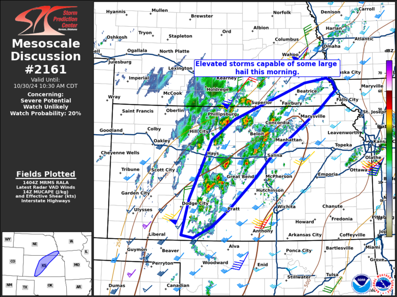
   SUMMARY...Elevated storms capable of some large hail are possible
   this morning from portions of central Kansas into southeast
   Nebraska.

   DISCUSSION...Lightning has increased across central Kansas as ascent
   increases across the Plains within a moderately unstable
   environment. The TOP 12Z RAOB indicated around 1300 J/kg MUCAPE and
   continued low-level moisture advection and mid-level cooling should
   increase instability as the morning progresses. Effective shear was
   actually quite weak at 12Z with a 60 knot low-level jet near the
   low-level jet and 60 knots at 7km with weaker flow between this
   layer. However, as the mid-level jet streak approaches the region
   and nocturnal influences of the low-level jet reduce, a more
   favorable, gradually increasing wind profile with height is expected
   to develop by late morning to early afternoon. As instability and
   the wind profile improve, eventually expect some supercells to
   develop along or slightly on the cool side of the cold front.
   Isolated large hail will be the primary threat from this activity
   later this morning and into the early afternoon. A watch likely will
   not be needed in the short term.

   ..Bentley/Gleason.. 10/30/2024

   ...Please see www.spc.noaa.gov for graphic product...

   ATTN...WFO...EAX...OAX...TOP...ICT...GID...DDC...

   LAT...LON   37110000 37939979 39269915 39729849 40519649 40619585
               40539567 40359558 39959604 38889745 38299801 37699865
               37329913 37069966 37110000
|
|
|
Top/All Mesoscale Discussions/Forecast Products/Home |
|
Source link


