|
|
| Mesoscale Discussion 1988 | |
| < Previous MD | |

|
|
   Mesoscale Discussion 1988
   NWS Storm Prediction Center Norman OK
   0315 PM CDT Sun Aug 25 2024

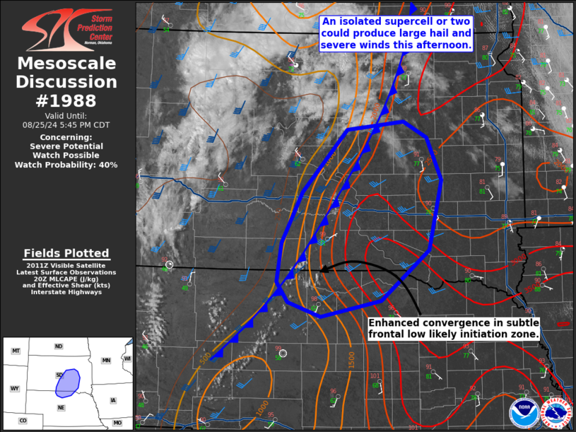
   Areas affected...Far north-central Nebraska and south-central South
   Dakota

   Concerning...Severe potential...Watch possible

   Valid 252015Z - 252245Z

   Probability of Watch Issuance...40 percent

   SUMMARY...Though isolated, a supercell or two could pose a risk for
   large hail and severe wind gusts this afternoon. A watch is possible
   this afternoon.

   DISCUSSION...Towering cumulus have begun to develop within a weak
   frontal low near Valentine/Ainsworth. This area and adjacent
   south-central South Dakota will likely be the initiation zone for
   thunderstorms later this afternoon. Large-scale ascent is quite weak
   within the upper ridge and the timing of initiation is not
   completely certain. Most short-term guidance would suggest
   developing between 21-22Z. Morning observed soundings from the
   region show very steep lapse-rates aloft. Moderate southwesterly
   flow aloft is supporting 35-45 kts of shear. Initial development
   would likely be supercellular with a risk for large hail (primarily
   1-1.75 in.) and severe wind gusts (60-75 mph). There is a
   conditional threat for very large hail, but generally warm
   temperatures in the profile as well as modest flow at anvil level
   suggest that threat would be low. The tornado threat will be low on
   account of weak low-level winds and large temperature-dewpoint
   spreads at the surface; however, storms near the boundary could
   stretch low-level vorticity and produce a brief tornado. Storm
   coverage appears that it will remain isolated, although storms could
   be intense. A watch could be considered this afternoon as convective
   trends warrant.

   ..Wendt/Guyer.. 08/25/2024

   ...Please see www.spc.noaa.gov for graphic product...

   ATTN...WFO...FSD...ABR...LBF...UNR...

   LAT...LON   42619892 42419994 42600051 42850070 43330062 43970027
               44759950 44849853 44659813 44119788 43259809 42619892
|
|
|
Top/All Mesoscale Discussions/Forecast Products/Home |
|


