|
|
| Mesoscale Discussion 1908 | |
| < Previous MD | |

|
|
   Mesoscale Discussion 1908
   NWS Storm Prediction Center Norman OK
   0303 PM CDT Thu Aug 15 2024

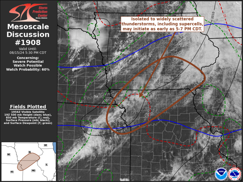
   Areas affected...parts of northeast Kansas...northwest Missouri and
   southern Iowa

   Concerning...Severe potential...Watch possible

   Valid 152003Z - 152230Z

   Probability of Watch Issuance...60 percent

   SUMMARY...Isolated to widely scattered thunderstorm development
   appears possible as early as 5-7 PM CDT.  One or two supercells may
   evolve, posing a risk for large hail, locally damaging wind gusts
   and perhaps some potential for a tornado.

   DISCUSSION...Low-level forcing for convective development remains
   generally weak and/or unclear.  However, a seasonably moist
   boundary-layer along and east of the southeastward advancing weak
   surface troughing is becoming moderately unstable across parts of
   northeast Kansas into southern Iowa, where CAPE now appears in
   excess of 2000 J/kg and mid-level inhibition is eroding.  This is
   being aided by both continuing insolation and mid-level cooling
   associated with a notable short wave perturbation pivoting across
   the mid to lower Missouri Valley vicinity.  As the exit region of a
   40-70 kt westerly jet in the 500-300 mb layer noses across the
   stronger destabilization, vertical shear is becoming increasingly
   conducive to supercells.  Although timing of thunderstorm initiation
   remains uncertain, isolated to widely scattered thunderstorms appear
   possible as early as 22-00z, particularly within a corridor
   east-southeast of St. Joseph MO through the Missouri/Iowa border
   vicinity.

   ..Kerr/Thompson.. 08/15/2024

   ...Please see www.spc.noaa.gov for graphic product...

   ATTN...WFO...LSX...DVN...DMX...EAX...OAX...TOP...

   LAT...LON   40219546 41349399 41859248 41099091 40429178 38959464
               39279575 40219546
|
|
|
Top/All Mesoscale Discussions/Forecast Products/Home |
|


