|
|
| Mesoscale Discussion 1875 | |
| < Previous MD Next MD > | |

|
|
   Mesoscale Discussion 1875
   NWS Storm Prediction Center Norman OK
   0351 PM CDT Fri Aug 09 2024

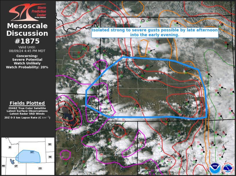
   Areas affected...Parts of southern/central WY into extreme northeast
   UT/southeast ID

   Concerning...Severe potential...Watch unlikely

   Valid 092051Z - 092245Z

   Probability of Watch Issuance...20 percent

   SUMMARY...Isolated strong to severe gusts will be possible from late
   afternoon into the early evening.

   DISCUSSION...Multiple areas of building cumulus are noted across
   parts of southern/central WY this afternoon, with a strong storm
   over far northern UT. While low-level moisture remains rather
   modest, a combination of diurnal heating and relatively steep lapse
   rates have resulted in modest destabilization, with MLCAPE
   increasing to near or above 500 J/kg across much of the region.
   Generally unidirectional wind profiles with moderate westerly
   midlevel flow are supporting effective shear of 30-40 kt, sufficient
   for modestly organized cells/clusters as storms mature.

   Initial storms could pose a nonzero hail threat, but one or more
   outflow-driven clusters may evolve with time, as storms move through
   a well-mixed environment. Steep low-level lapse rates will support
   potential for strong to locally severe gusts as convection spreads
   eastward from late afternoon into the early evening.

   ..Dean/Goss.. 08/09/2024

   ...Please see www.spc.noaa.gov for graphic product...

   ATTN...WFO...CYS...RIW...SLC...PIH...

   LAT...LON   41150838 41141054 41291092 41591169 42151169 42971069
               43470985 43360752 43310709 42960589 42190559 41490554
               41120557 41070616 41170738 41150838
|
|
|
Top/All Mesoscale Discussions/Forecast Products/Home |
|


