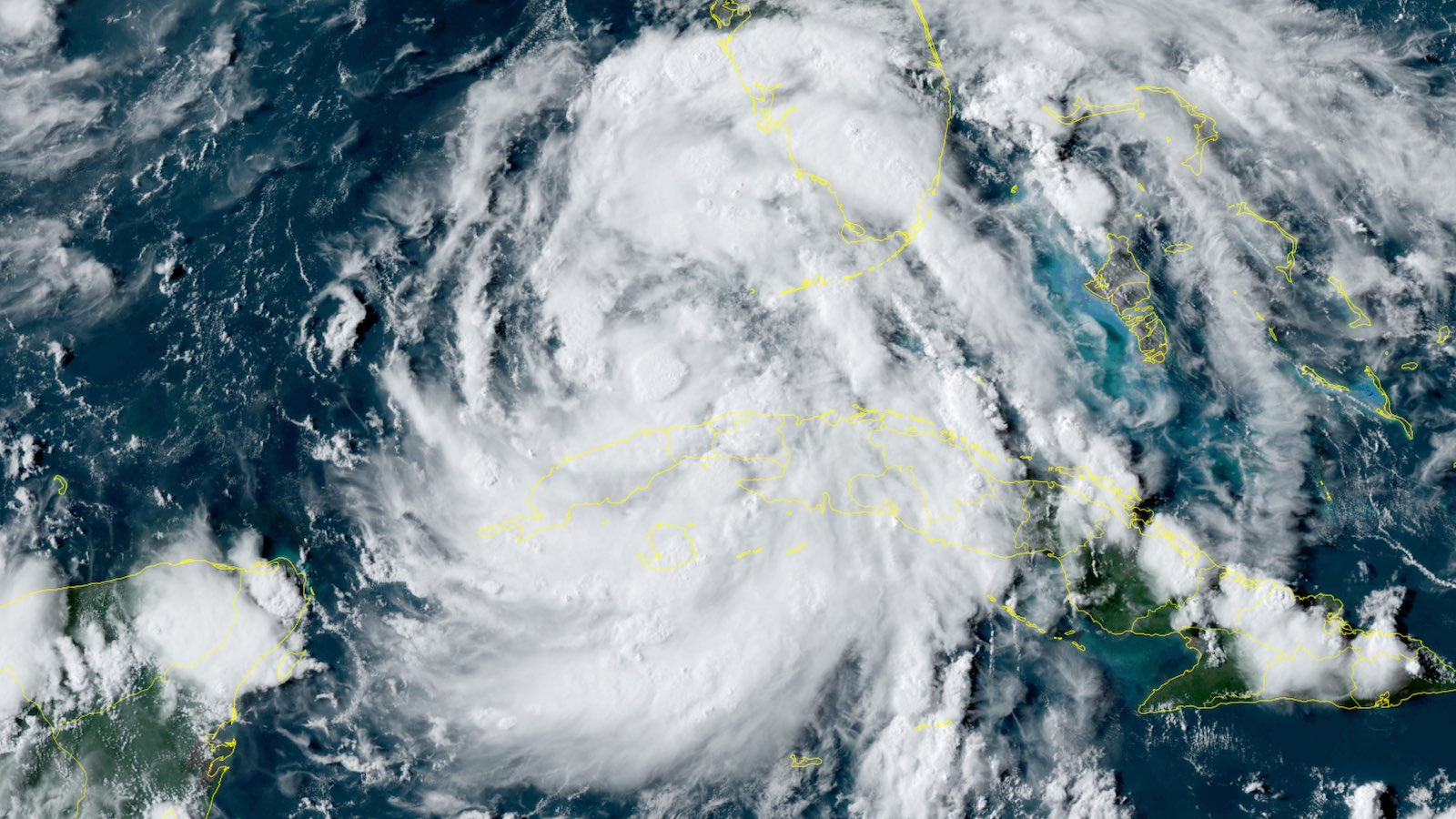
After becoming the Atlantic’s fourth named storm of the 2024 season on Saturday, Tropical Storm Debby was about to embark on what could be a week-long hydrological rampage across the coastal U.S. Southeast. Debby is expected to reach hurricane strength before making landfall in early Monday in the Big Bend of Florida’s northeast Gulf Coast, bringing storm surge and high winds. But Debby’s greatest impact will likely arise from days of torrential rainfall, as steering currents may leave Debby stranded and lingering for days near the Southeast U.S. coast.
As of 5 p.m. EDT Saturday, newly upgraded Debby was centered about 100 miles west-southwest of Key West, Florida, with top sustained winds of 40 mph. Debby’s upper-level circulation was unusually large and robust for a minimal-strength tropical storm, with showers and thunderstorms (convection) in multiple broad bands extending from well south of Cuba to the west central coast of Florida. Conditions were favorable for continued development, with near-record ocean temperatures near 30 degrees Celsius (86°F), light wind shear of 5-10 knots, and a mid-level relative humidity of 65 to 70 percent.
Up through Saturday, Debby was being steered mainly by a strong upper-level ridge over the Atlantic Ocean, which drove the system west-northwest along the length of Cuba and into the southeast Gulf of Mexico. This weekend an upper-level trough diving into the eastern United States will help tug Debby more northward and northeastward. There is strong agreement among models on Debby’s expected recurvature, which would bring it into the northeast Gulf Coast of Florida Monday morning.
Debby’s size will inhibit rapid intensification until the storm’s central core sharpens. However, with extremely warm sea surface temperatures beneath its path, Debby will then have a chance to reach hurricane strength from late Sunday up through landfall, as predicted by the National Hurricane Center. Over time, the storm’s expansive shield of convection coupled with a decelerating motion will add to a formidable risk of widespread flooding.
Extreme rainfall likely for northeastern Florida, Georgia, and South Carolina
The trough of low pressure pulling Debby to the northeast is not expected to be strong enough to finish the job, leaving the storm stranded in a region of weak steering currents near the Southeast U.S. coast for multiple days. The extended deluge would begin on Monday, when the storm is expected to be moving at 7 to 9 mph. This would rank among the slowest 20% of tropical cyclone forward speeds for the region. As Debby slows even more, the storm is predicted to take 36 to 48 hours to cross from Florida’s Big Bend coast to the Georgia coast – a distance of only around 100 to 150 miles.
The National Hurricane Center predicts 8-12 inches of rain for northeastern Florida through the coastal plain of Georgia and South Carolina (Fig. 1 below), with 12-16 inches forecast within about 50 miles of the coast from near Jacksonville, FL, to Charleston, SC. The 12Z Saturday run of the GFS model predicted rainfall amounts in excess of 20 inches near the Georgia-South Carolina border. This might challenge the South Carolina all-time state precipitation record for a tropical cyclone: 23.63 inches from Hurricane Florence in 2018.


NOAA’s Excessive Rainfall Discussion at 4 p.m. EDT Saturday placed northeastern Florida through the coastal plain of Georgia and South Carolina in a “Moderate Risk” of heavy rainfall for Monday and Monday night, with smaller Moderate Risk areas projected for Sunday along Florida’s Big Bend coast and for Tuesday along the Georgia/South Carolina coast. The outlook warned that an upgrade to High Risk for Monday was “probable” as confidence increases on the timing and location of the heaviest rains. Only about 4% of days in the U.S. feature High Risk areas, but they account for about one-third of all flood fatalities and some 80% of flood-related damage.
Heavy rains exceeding six inches or more could extend into southern and eastern parts of North Carolina, depending on the system’s ultimate speed and track. And moisture channeled along the coast well north of the tropical cyclone itself could bring widespread totals of 4-6 inches all the way to southern New England by week’s end.
Although most of South Carolina is in moderate to severe drought, widespread rains in excess of 10 inches are sure to cause damaging flooding, especially near the coast where onshore winds and a storm surge will prevent rainwater from draining efficiently.
The exact magnitude of the flood threat to Georgia and the Carolinas is difficult to estimate, since it will heavily depend on how much time the center remains offshore, potentially allowing Debby to intensify. With weak steering currents and a storm likely to be very near the coast, slight and unpredictable wobbles in the track will make big differences in how much rain Debby ultimately dumps.
Storm surge
Debby is predicted to bring a peak storm surge of 3-5 feet near and to the right of where it makes landfall. The surge and battering waves of the storm will cause significant damage and erosion to beaches and dunes that were heavily impacted last year by the landfall of Hurricane Idalia, which brought a storm surge of 8-12 feet to the Big Bend and 3-5 feet to Tampa Bay.
High tide at St. Marks in Florida’s Big Bend region is early Monday morning at 12:44 a.m. EDT (4:55Z) and again at 11:32 a.m. EDT (15:32Z); low tide is at 7:15 a.m. (11:26Z). The difference in water level between high and low tide is only about 0.8 feet, so the timing of Debby’s landfall will not be a huge factor in determining how much coastal flooding occurs. The 12Z Saturday runs of five top hurricane tracking models predicted that landfall would occur between 3-11 a.m. EDT (8Z-15Z) Monday morning. The 11 a.m. EDT Saturday NHC forecast called for a landfall near 12Z Monday (8 a.m. EDT), which is near the time of low tide.
Source link


