|
|
| Mesoscale Discussion 1797 | |
| < Previous MD Next MD > | |

|
|
   Mesoscale Discussion 1797
   NWS Storm Prediction Center Norman OK
   0434 PM CDT Fri Aug 02 2024

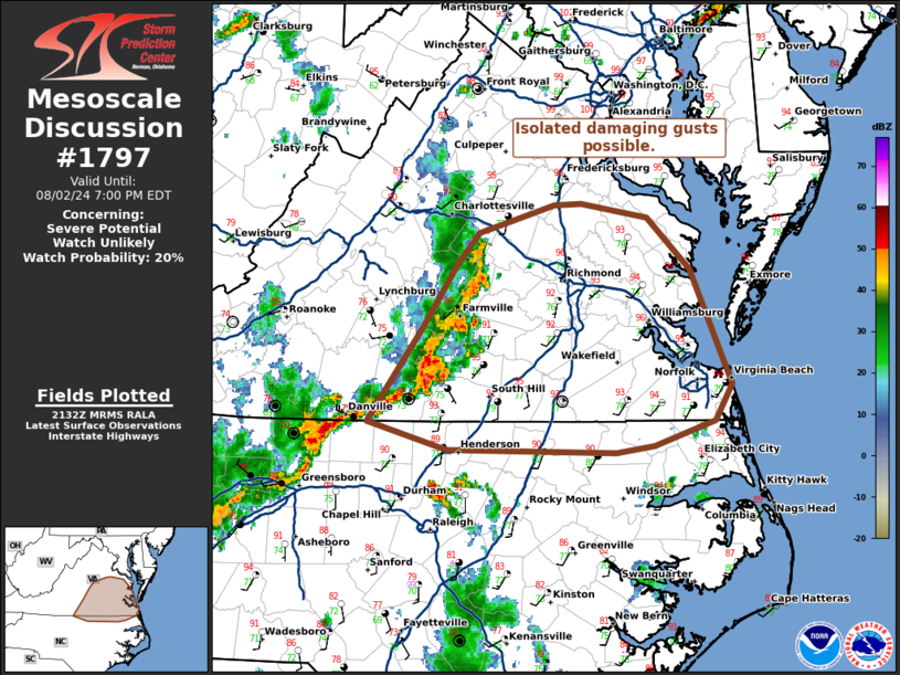
   Areas affected...portions of eastern VA and far northern NC

   Concerning...Severe potential...Watch unlikely

   Valid 022134Z - 022300Z

   Probability of Watch Issuance...20 percent

   SUMMARY...A cluster of strong to occasionally severe storms may pose
   a risk for isolated wind damage late this afternoon into the
   evening.

   DISCUSSION...Over the last couple of hours, scattered thunderstorms
   ongoing over the central Appalachians have gradually coalesced into
   a loosely organized cluster across parts of southern VA and far
   northern NC. The environment ahead of this cluster is very warm and
   unstable with temperatures in the 90s F and 3000+ J/kg of MLCAPE.
   However, very limited deep-layer shear is in place, with most VADs
   showing generally less than 20 kt. While modest in organization, the
   fairly pronounced cold pool moving into plentiful buoyancy should
   continue to support strong transient updrafts. The high PWAT air
   mass and pulse-like nature of the convection should also support
   occasional stronger downdrafts within the collapsing cores. Isolated
   damaging winds are possible along with a low-end risk of higher
   gusts to 50-60 mph. Displaced away from deeper forcing for ascent
   and flow aloft, storm organization will remain tied to the
   propagation along and ahead of the outflow. This should remain
   fairly limited in scope, and a WW is unlikely.

   ..Lyons/Smith.. 08/02/2024

   ...Please see www.spc.noaa.gov for graphic product...

   ATTN...WFO...AKQ...LWX...RAH...RNK...

   LAT...LON   37897821 38087755 38107730 37997671 37637633 37007605
               36817596 36547611 36367665 36327699 36337849 36547921
               37247870 37657841 37897821
|
|
|
Top/All Mesoscale Discussions/Forecast Products/Home |
|


