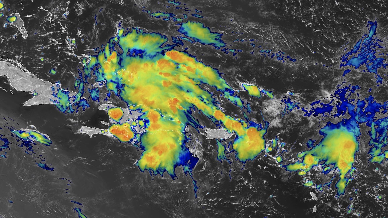
Tropical activity in the Atlantic normally picks up as July segues into August. True to form, a large tropical wave now labeled Invest 97L, centered near Haiti at midday Thursday, will be heading toward the southeastern Gulf of Mexico this weekend. This system appears likely to become Debby, the fourth named storm of the year. Its future is highly uncertain, but models are starting to gravitate toward the idea of a long-lived, slow-moving tropical storm or hurricane that could dump colossal amounts of rain along and near parts of the eastern Gulf Coast. And a coast-scraping track along or near the Southeast U.S. shore can’t yet be ruled out.
On Thursday, 97L was spreading heavy rains over Hispaniola, the southeastern Bahamas, and adjacent areas. However, the system was encountering and ingesting too much dry air for these scattered showers and thunderstorms (convection) to coaslesce into a more organized system, as the mid-level relative humidity was only around 55 percent. Otherwise, conditions were favorable for development, with light to moderate wind shear of 5-15 knots and near-record sea surface temperatures of 29 degrees Celsius (84°F).
In its Tropical Weather Outlook issued at 2 p.m. EDT Thursday, the National Hurricane Center gave 97L a 30% chance of becoming at least a tropical depression by Saturday, and a 70% chance by next Thursday. These odds, especially for the two-day period, can be expected to rise further as the weekend draws nearer. The first hurricane-hunter flight into 97L is tentatively set for Friday afternoon.
Forecast for 97L
The course of 97L over the next week or more will be shaped by three systems, all located to its north:
- a strong ridge of high pressure across the western and central U.S.
- a strong ridge in the Atlantic associated with the Azores-Bermuda High
- a weakness in between (a trough of low pressure)
At first, 97L will be steered mainly by the Atlantic ridge, which is positioned to drive the system west-northwest along the length of Cuba. Along this track, 97L will encounter a increasingly moist environment, with the humidity projected to climb to 65-70% by Saturday. Wind shear should remain light to moderate through the weekend, and land interaction with the islands will decrease as 97L emerges into the open southeastern Gulf on Saturday and Sunday. All these factors will make it easier for 97L to consolidate into a tropical depression or tropical storm.
The main track uncertainty with 97L involves an upper-level trough of low pressure moving across the Great Lakes on Thursday. This trough will elongate as it moves into the weakness across the Appalachians and Eastern Seaboard over the weekend. By early next week, the weakening trough will move off the U.S. East Coast as upper-level high pressure gradually reasserts itself, likely slowing the movement of 97L.
Forecast models have been swinging back and forth between two camps that pose distinctly differing threats:
- Scenario 1: If 97L develops quickly and is positioned far enough north by late in the weekend, the eastern U.S. trough may be able to pull the system into Florida’s Gulf Coast and then slowly northeastward along or near the Southeast U.S. coast. Such a track could bring heavy rains, high seas, and other impacts to eastern Georgia and the Carolinas as the week unfolds, depending on how far offshore (or how far inland) 97L were to track and how slowly it moves.
- Scenario 2: If 97L intensifies more slowly and/or develops a bit further south, it is more likely to be trapped in the Gulf early next week as the western/central U.S. ridge builds eastward. This would likely cause 97L to wander for many days over the northeastern Gulf of Mexico and adjacent land areas, posing a serious heavy-rain threat.
Sea surface temperatures in the eastern Gulf of Mexico are record-warm (see Fig. 1 below), and will provide plenty of moisture to feed heavy rains. The warm waters also extend to great depth over parts of the eastern Gulf, which could help fuel rapid intensification.


The European and GFS forecast models have been trending toward Scenario 2 (the eastern Gulf stall) over the last day or so. But operational runs of these and other models have varied wildly. So at this point, it’s best to see the models as offering very general guidance on the kinds of things that could happen next week, rather than serving as any definitive forecast. The model runs may be especially variable until 97L develops a more focused center of circulation.
By this weekend, it should become more apparent which of the two scenarios above is more likely. Even beyond that point, weak steering currents, slow movement, and near-shore positioning could make it unusually tough to predict 97L’s track, strength, and impacts with precision.
Carlotta expected to become the Northeast Pacific’s first hurricane of 2024
After its slowest start on record, hurricane season is finally gaining traction in the Northeast Pacific. Tropical Storm Carlotta, located about 455 miles west-southwest of Manzanillo, Mexico, as of 11 a.m. EDT Thursday, was packing top sustained winds of 60 mph. Carlotta is predicted to become the Northeast Pacific’s first hurricane of the year by Friday as it heads safely west-northwest away from land, possibly peaking at or near major hurricane strength (Category 3) on Saturday before encountering cooler waters.
This is only the second time in satellite-era data going back to 1970 that the Northeast Pacific has made it to August without a hurricane, as noted by Phil Klotzbach (Colorado State University). The region’s latest first hurricane on record was Ignacio, which reached hurricane strength on August 24, 2003.
We help millions of people understand climate change and what to do about it. Help us reach even more people like you.
Source link


