|
|
| Mesoscale Discussion 1698 | |
| < Previous MD | |

|
|
   Mesoscale Discussion 1698
   NWS Storm Prediction Center Norman OK
   0257 PM CDT Tue Jul 23 2024

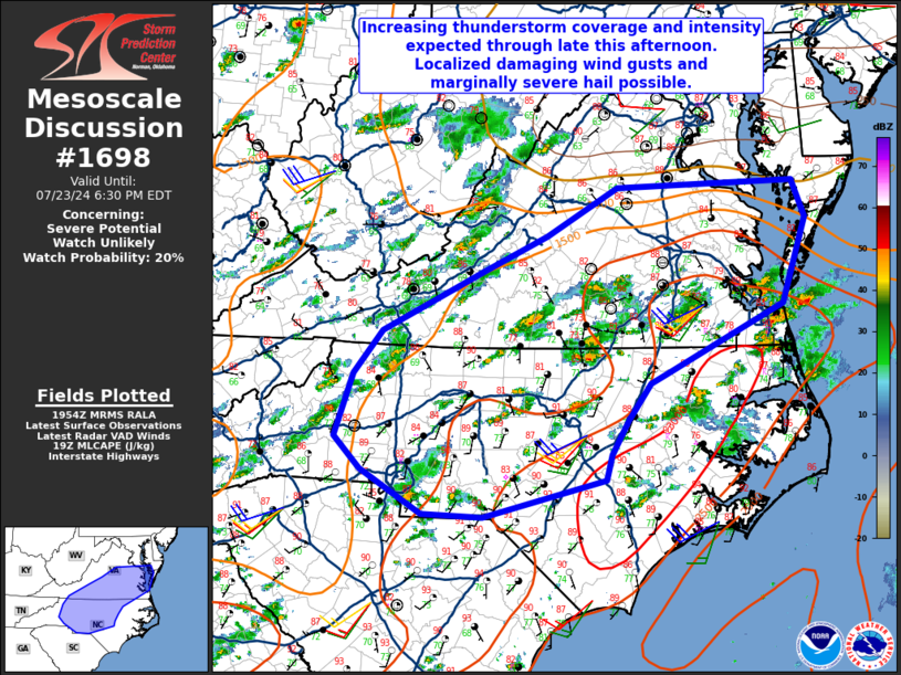
   Areas affected...Central North Carolina and portions of southern and
   southeastern Virginia

   Concerning...Severe potential...Watch unlikely

   Valid 231957Z - 232230Z

   Probability of Watch Issuance...20 percent

   SUMMARY...An increase in both thunderstorm coverage and intensity is
   expected across central NC and portions of southern VA over the next
   2-3 hours. Localized damaging wind gusts up to 60 mph and hail
   around 0.75-1.25" will be possible with a few of the thunderstorms.

   DISCUSSION...Recent observational trends indicate an increase in
   deep moist convective coverage across central NC and southern VA.
   Substantial deep layer moisture remains in place across the
   Mid-Atlantic, with estimated PWATs near or exceeding daily
   climatological 90th percentiles. Subtly increasing ascent associated
   with at least one upstream mid-level perturbation within
   southwesterly flow aloft will continue to aid in scattered
   thunderstorm development through at least late this afternoon.
   Widespread updraft organization should remain limited across most
   this region due to modest deep layer effective shear. However, some
   stronger mid to upper flow over VA may continue to yield 30-35 kt of
   effective shear along and north of the VA/NC border, with the
   possibility of transient supercell structures capable of producing
   marginally severe hail. The overall severe threat with this activity
   will be the potential for damaging wind gusts up to 60 mph via
   precipitation loading/wet microbursts, especially with any merging
   linear clusters. Even with increasing thunderstorm coverage, the
   severe weather threat should remain relatively localized and a WW is
   not anticipated at this time.

   ..Barnes/Smith.. 07/23/2024

   ...Please see www.spc.noaa.gov for graphic product...

   ATTN...WFO...AKQ...LWX...RAH...RNK...CAE...GSP...

   LAT...LON   35638163 36268141 36718105 37317977 37687897 38177808
               38227585 37857569 36977600 36297742 36177767 35807795
               35457817 35207823 34827978 34858054 35308130 35638163
|
|
|
Top/All Mesoscale Discussions/Forecast Products/Home |
|


