|
|
| Mesoscale Discussion 1568 | |
| < Previous MD | |

|
|
   Mesoscale Discussion 1568
   NWS Storm Prediction Center Norman OK
   1027 AM CDT Wed Jul 10 2024

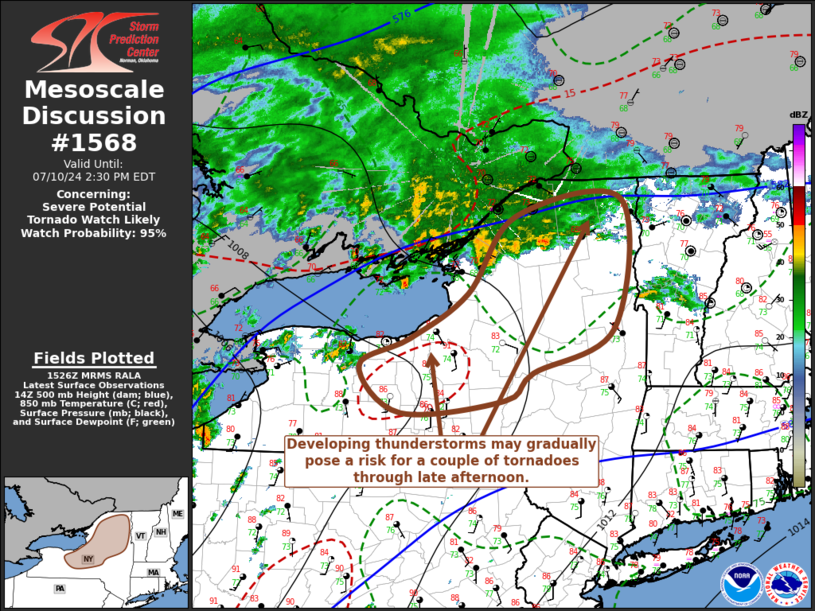
   Areas affected...much of central through northern New York State

   Concerning...Severe potential...Tornado Watch likely

   Valid 101527Z - 101830Z

   Probability of Watch Issuance...95 percent

   SUMMARY...Thunderstorms may develop supercell structure and pose
   increasing potential for a couple of tornadoes across parts of the
   Finger Lakes and Mohawk Valley into the Adirondacks and Champlain
   Valley vicinity through 2-6 PM EDT.

   DISCUSSION...Downstream of a modest surface low associated with the
   remnants of Beryl, boundary-layer destabilization is well underway
   in response to insolation and moistening, across the Finger Lakes
   and Mohawk Valley into Adirondacks.  This is occurring beneath the
   leading edge of notably warm and warming mid-level air (including
   roughly the -6 C isotherm at 500 mb), which is forecast to continue
   advecting northeastward across the lower Great Lakes and New England
   through this afternoon.

   As destabilization continues, thunderstorm probabilities appear
   likely to increase this afternoon with gradually deepening
   convective development.  Deep-layer shear to the east of the lower
   Great Lakes is already sufficient for the development of supercell
   structures, with a belt of 30 kt flow around 850 mb enhancing
   low-level shear across the southern tier of New York into areas
   near/east of Lake Ontario, where modest clockwise-curved low-level
   hodographs appear most conducive to the risk for a tornado or two,
   in the presence of lower/mid 70s F dew points.  Models suggest that
   this environment will tend to shift from the lee of Lake Ontario
   toward the Champlain Valley vicinity through 18-22Z.

   ..Kerr/Guyer.. 07/10/2024

   ...Please see www.spc.noaa.gov for graphic product...

   ATTN...WFO...BTV...ALY...BGM...BUF...

   LAT...LON   43267677 43767590 44597519 44787360 43387373 42897493
               42607535 42457689 42977751 43267677
|
|
|
Top/All Mesoscale Discussions/Forecast Products/Home |
|
Source link


