United States Storm Reports Interactive Map Today

The Preliminary Storm Report or LSR is a NWS text product that relays information, normally received from external sources (e.g. weather spotters, local officials, media, public, etc.), about a specific weather event (hail `{`size`}`, wind gust or damage, tornado, various wintry precipitation types and amounts, rainfall amounts, etc.) The Storm Reports page is organized based on reports received from 1200 UTC to 1159 UTC the next day. Data is updated every 10 minutes.

Click on storm report inside map for detailed data.
Scroll down for storm reports from yesterday.

T = Tornado | W = Wind | H = Hail
If the storm reports text data fields are blank or missing information below, there are no storm reports for today.

Tornado Reports Today

TimeF_ScaleLocationCountyStateLatLonComments

Hail Reports Today

Hail sizes are measured in 1/100 of an inch (175 = 1.75``)
TimeSizeLocationCountyStateLatLonComments
23441254 SW StrawnEastlandTX32.5-98.53Report from mPING. (FWD)
23521752 S MingusErathTX32.51-98.42(FWD)

Wind Reports Today

Wind speed gusts are measured in MPH
TimeSpeedLocationCountyStateLatLonComments

United States Storm Reports Interactive Map Yesterday

T = Tornado | W = Wind | H = Hail
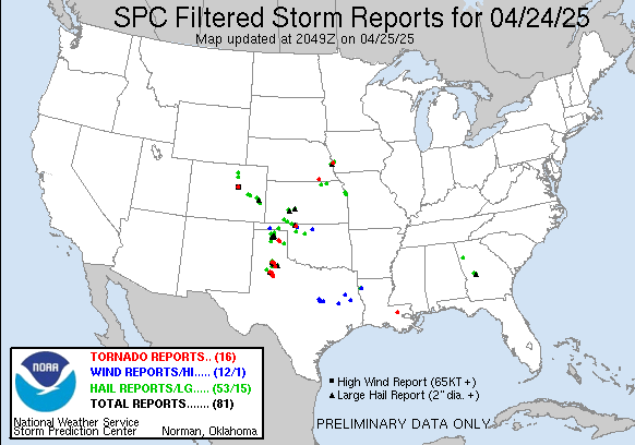
Tornado Reports Yesterday

TimeF_ScaleLocationCountyStateLatLonComments
1848UNK10 WSW HuxleyShelbyTX31.7-94.03This tornado began SE of Shelbyville near the Hurstown community at the intersection of TX Hwy 87 and CR 2130. Most of the damage consisted of snapped and uprooted tree (SHV)
0133UNK3 ESE VivianCaddoLA32.86-93.94A tornado began just south of HWY 20 between Vivian and Hosston and then crossed Black Bayou Lake. After crossing the Lake... tree damage was found on the north-central (SHV)

Hail Reports Yesterday

Hail sizes are measured in 1/100 of an inch (175 = 1.75``)
TimeSizeLocationCountyStateLatLonComments
21101003 E MahtowaCarltonMN46.57-92.56Facebook message with image and coin reference. (DLH)
21111005 NE MahtowaCarltonMN46.62-92.56Dimes to quarter sized hail with over an inch of it on the ground and it is still hailing. (DLH)
21141001 SW Scotts CornerCarltonMN46.59-92.45Report from mPING: Quarter (1.00 in.). (DLH)
2115100WrenshallCarltonMN46.62-92.38Time estimated from radar. (DLH)
21291255 W South RangeDouglasWI46.62-92.09Video of half dollar size hail shared via social media. Largest hail was bigger than quarters. Most were penny to nickel size. Hail accumulated deep enough to shovel. (DLH)
23041004 NW Dodge CenterDodgeMN44.07-92.91(ARX)
23151253 SSE BerneDodgeMN44.13-92.76(ARX)
2315125ZumbrotaGoodhueMN44.3-92.67One inch hail also reported by another spotter in Zumbrota and also by a broadcast meteorologist. Time based on radar. (MPX)
0000125ElginWabashaMN44.14-92.25(ARX)
00351004 W PloverPortageWI44.45-89.62(GRB)
0036125PloverPortageWI44.45-89.54(GRB)
0040100PloverPortageWI44.45-89.54(GRB)
02071003 NW WaupacaWaupacaWI44.37-89.1Report from mPING: Quarter (1.00 in.). (GRB)

Wind Reports Yesterday

Wind speed gusts are measured in MPH
TimeSpeedLocationCountyStateLatLonComments
0044612 SSW Garden CityBlue EarthMN44.02-94.1761 mph gust measured by personal weather station. (MPX)
0225UNKEast JordanCharlevoixMI45.16-85.13Large tree downed onto home. Roof blown off of campground building. Time approximated from radar and other nearby wind reports. (APX)

This data is courtesy of the NWS Storm Prediction Center