|
|
| Mesoscale Discussion 1561 | |
| < Previous MD | |

|
|
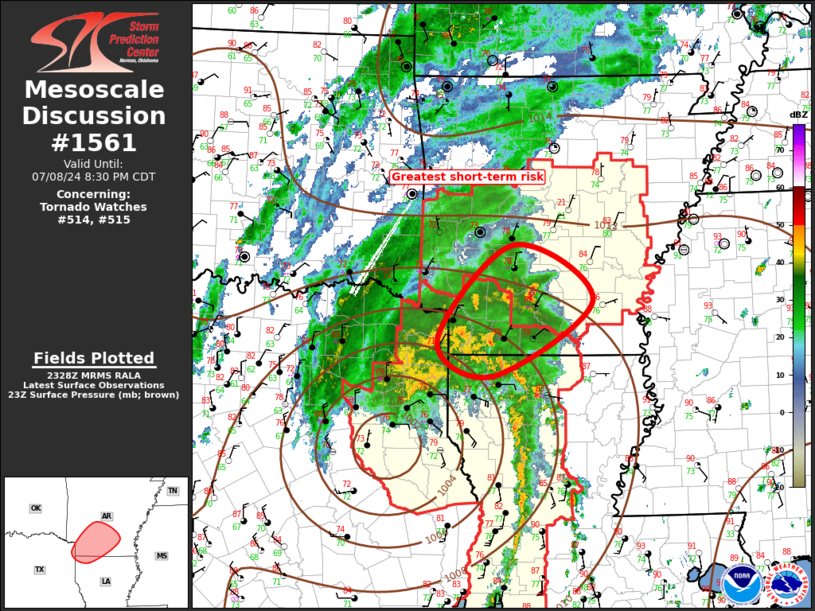
Mesoscale Discussion 1561 NWS Storm Prediction Center Norman OK 0629 PM CDT Mon Jul 08 2024 Areas affected...TS Beryl Concerning...Tornado Watch 514...515... Valid 082329Z - 090130Z The severe weather threat for Tornado Watch 514, 515 continues. SUMMARY...Tornado threat will be most concentrated from northern Louisiana into central Arkansas this evening. DISCUSSION...Center of TS Beryl is lifting northeast across northeast TX early this evening. Latest radar data suggests the remnant circulation is just south of Longview. As such, strongest low-level shear is now focusing across the ArkLaTex, especially into southern AR where values continue to increase. Latest VWP data from SHV depicts weakening 0-3km SRH values, while 0-3km values are showing a marked increase as far northeast as LZK (300 m2/s2). While a few supercells linger at lower latitudes over central LA, the strongest longer-lived supercells are now concentrated from northwest LA into southwest AR. Over the next several hours the primary corridor of concern will orient itself from north of SHV toward LIT. ..Darrow.. 07/08/2024 ...Please see www.spc.noaa.gov for graphic product... ATTN...WFO...LZK...SHV... LAT...LON 33209421 34399308 33689188 32759337 33209421 |
|
|
Top/All Mesoscale Discussions/Forecast Products/Home |
|


