Hurricane Beryl pounded the Houston area with power-cutting winds, heavy rain, and storm surge on Monday morning, July 8, after making landfall at 5 a.m. EDT near Matagorda, Texas, about 90 miles southwest of Galveston. At landfall, Beryl was a strengthening Category 1 hurricane with 80 mph winds and a central pressure of 989 mb. At landfall, Beryl had a large eye with a diameter of 32 miles, which gave the hurricane a relatively large radius of maximum winds that prevented rapid intensification. However, Beryl maintained its hurricane-force strength as its stronger right-hand side moved directly over central Houston, bringing the city some of its strongest winds since Hurricane Ike in 2008.
Beryl’s assault on Houston followed a record-breaking run in the Caribbean that was fueled by exceptionally warm sea surface temperatures and deep oceanic heat content, both at unparalleled levels for late June and early July. The broiling oceanic heat allowed Beryl to surge time and again beyond expectations, overpowering wind shear that typically snuffs out early tropical cyclones.
Beryl’s trail of broken records and the oceanic heat that’s helped them happen
Beryl’s catalog of trouble includes its three landfalls: the Windward Island of Carriacou, Mexico’s Yucatán Peninsula, and the Texas coast — plus a damaging close scrape along the south coast of Jamaica. As of early Monday, Beryl had taken at least 13 lives, including one from a falling tree near Houston, and damaged or destroyed hundreds of structures, with a full accounting of damage still to come.
Beryl has also barreled its way through numerous records, including:
- First Atlantic Category 4 storm on record in June
- Earliest Category 5 storm on record in the Atlantic, beating the previous record-holder (Emily of 2005) by 15 days
- Most accumulated cyclone energy of any Atlantic hurricane prior to August
- Farthest east a June hurricane has ever formed in the tropical Atlantic
- Fastest rate of strengthening for any June hurricane: 65 mph in 24 hours, from a tropical storm to a Category 4 hurricane
Because of Beryl, Atlantic hurricane season activity so far this season is typical of what we usually see by the beginning of September and is about three times higher than what the Western Pacific has observed so far this year.
Large parts of the North Atlantic experienced record-warm sea surface temperatures for most of 2023 and most of the first half of 2024, part of a startling global surge in oceanic heat. With relentless longer-term ocean warming underway as a result of human-caused climate change, it’s no surprise to see peaks on that upward curve surging well above record territory, although the extent and intensity of oceanic warmth in 2023-24 have been truly sobering.

Fortunately for people in hurricane country, an El Niño event in 2023 helped keep last year’s Atlantic’s hurricane season from fully leveraging this record heat. Only since late June 2024 have sea surface temperatures in the North Atlantic been running consistently below record-warm levels, though they are still higher than anything observed outside of last year (see Figure 2). The evolution toward La Niña over the past few months has paved the way for the 2024 Atlantic season to finally leverage some of these unusually warm waters.
Unlike most Category 5 storms, which typically leave a prominent cold wake behind them, Beryl hardly made a dent in the oceanic warmth across the Caribbean — an ominous portent for the peak months of hurricane season that still lie ahead.
Beryl’s winds aimed at central Houston
As documented by Kieran Bhatia (see Tweet below), Beryl passed closer to the core of Houston than any other recent hurricane, putting the storm’s “cone” right-hand side directly over downtown and subjecting millions of people to wind gusts over 80 mph. Houston International Airport recorded sustained winds of 58 mph, gusting to 83 mph, between 10-11 a.m. EDT; a wind gust of 89 mph was recorded at John Dunn Helistop, located on the south side of downtown Houston. As of 1 p.m. EDT Monday, more than 2.6 million customers in southeast Texas had lost power, according to poweroutage.com.
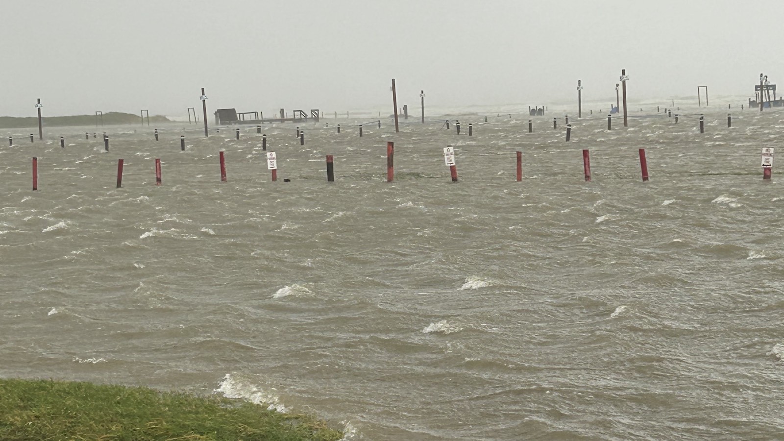
Beryl’s storm surge
Beryl brought a storm surge of three to four feet to tide gages along a swath of coast over 140 miles in extent to the right of where the center made landfall, from Matagorda to the Texas-Louisiana border. The surge caused major flooding at multiple locations. The high storm surge in Galveston Bay impeded runoff from heavy rains in the Houston area, leading to very high water levels on the Houston Ship Channel. Also called Buffalo Bayou, this waterway runs eastward from Houston into Galveston Bay, and a water level over 8.5 feet above high tide (mean higher high water) was recorded at the Manchester gauge, located about four miles east of downtown Houston. This was the second-highest water level since record-keeping began in 1998, behind the 10.45-foot reading during Hurricane Harvey in August 2017.
As of 1 p.m. EDT Monday, Beryl had been downgraded to a tropical storm, with top sustained winds of 65 mph, and was centered about 45 miles north-northwest of Houston, moving north-northeast at 13 mph. Beryl will gradually weaken as it plows across eastern Texas and on into the Mississippi Valley as a remnant low on Tuesday. A corridor of two- to four-inch rainfall, with some four-to-eight-inch totals likely, will extend from the Houston to St. Louis areas. Widespread disastrous flooding is not predicted, but flash flooding was present across the Houston area on Monday and may occur elsewhere along Beryl’s path.
The National Hurricane Center did an excellent job with its intensity forecast for Beryl’s final landfall. For each forecast made beginning at 11 a.m. EDT Thursday, NHC predicted the storm would be a Category 1 hurricane with 75-90 mph winds at the time of its Monday landfall on the Gulf Coast. The track forecast in the Gulf proved more challenging: Forecast models shifted dramatically to the right over time, and Beryl ended up hugging the right-hand side of the forecast “cone” for most of the weekend leading up to landfall. Note that the cone width is based on track errors from the prior five years, and the cone is designed to encompass two-thirds of possible locations at any point, so it’s entirely to be expected that some tracks will end up near or even beyond the cone edge at times.
We help millions of people understand climate change and what to do about it. Help us reach even more people like you.
Source link