|
|
| Mesoscale Discussion 1556 | |
| < Previous MD | |

|
|
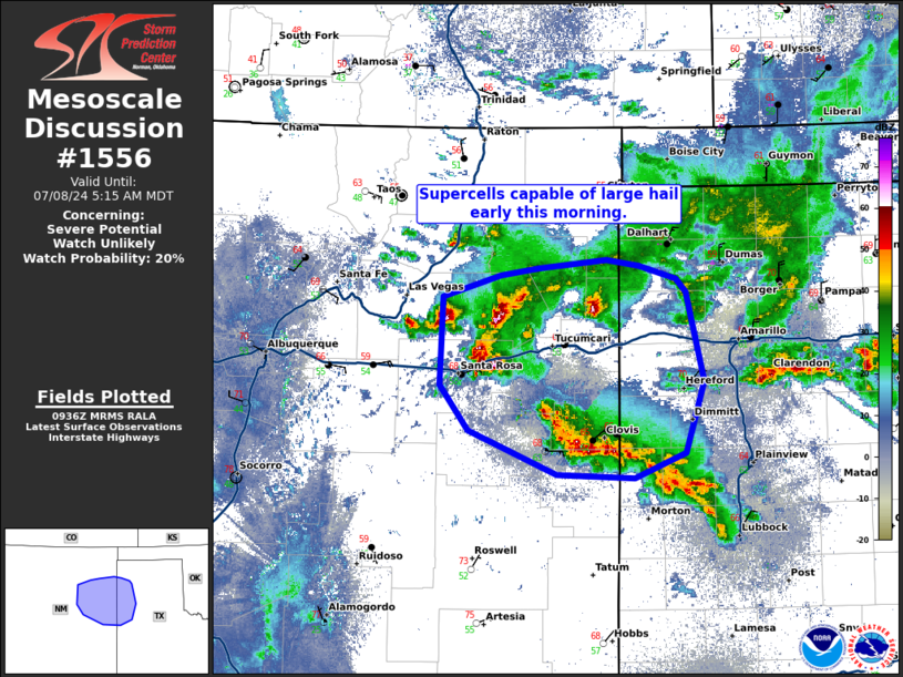
   Mesoscale Discussion 1556
   NWS Storm Prediction Center Norman OK
   0438 AM CDT Mon Jul 08 2024

   Areas affected...eastern New Mexico into the western Texas Panhandle

   Concerning...Severe potential...Watch unlikely

   Valid 080938Z - 081115Z

   Probability of Watch Issuance...20 percent

   SUMMARY...Several supercells have formed and may pose a large hail
   threat for a few hours as they move east-southeast early this
   morning.

   DISCUSSION...Elevated supercells have developed across eastern New
   Mexico as a mid-level trough approaches from the northwest. These
   storms have developed in a region with modest, but sufficient
   instability (1000 J/kg MUCAPE) and moderate shear (35-40 knots) per
   SPC mesoanalysis. Expect this environment to shift slowly east which
   may allow for some stronger storms to persist into the western Texas
   Panhandle near daybreak. MRMS MESH suggests 2+ inch hail is possible
   in some of the larger cores. This seems significantly overestimated,
   but some 1 to 1.5 inch hail is possible.

   This threat is expected to be too isolated/short lived for a severe
   thunderstorm watch.

   ..Bentley/Smith.. 07/08/2024

   ...Please see www.spc.noaa.gov for graphic product...

   ATTN...WFO...LUB...AMA...ABQ...

   LAT...LON   35570484 35760425 35810385 35890317 35840283 35730246
               35620235 34870217 34260236 34060288 34080368 34450457
               34830486 35570484
|
|
|
Top/All Mesoscale Discussions/Forecast Products/Home |
|