|
|
| Mesoscale Discussion 1555 | |
| < Previous MD | |

|
|
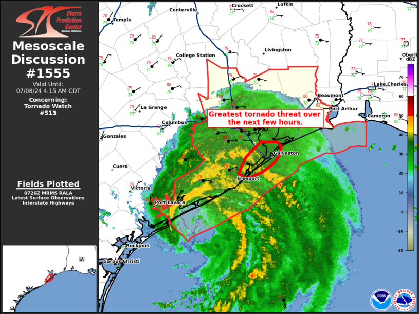
Mesoscale Discussion 1555 NWS Storm Prediction Center Norman OK 0228 AM CDT Mon Jul 08 2024 Areas affected...The Texas Coast near Galveston Island Concerning...Tornado Watch 513... Valid 080728Z - 080915Z CORRECTED FOR ADDITION OF HURRICANE BERYL ATTRIBUTION The severe weather threat for Tornado Watch 513 continues. SUMMARY...The greatest tornado threat with Hurricane Beryl will exist in the vicinity of Galveston Island over the next few hours. DISCUSSION...Two outer rain bands with embedded mini-supercells are rotating inland near Galveston Island early this evening. One of these storms produced an apparent tornado debris signature as it crossed the southern part of the island. As these rotating storms continue to pivot inland this morning, expect a continued tornado threat. However, this threat is expected to remain mostly confined to areas near the coast where the best wind profile and instability exists. Expect the greatest tornado threat to shift north through the early morning hours as outer bands shift north due to Hurricane Beryl's continued northward movement. ..Bentley.. 07/08/2024 ...Please see www.spc.noaa.gov for graphic product... ATTN...WFO...HGX... LAT...LON 29009519 29079532 29289520 29509497 29509472 29439466 29349466 29209476 29099495 29009519 |
|
|
Top/All Mesoscale Discussions/Forecast Products/Home |
|