2024-07-05 17:31:02
1720215617
|
|
| Mesoscale Discussion 1541 | |
| < Previous MD | |

|
|
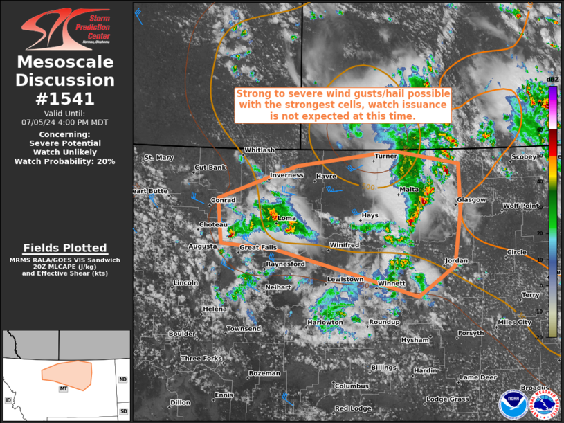
   Mesoscale Discussion 1541
   NWS Storm Prediction Center Norman OK
   0331 PM CDT Fri Jul 05 2024

   Areas affected...North-Central Montana

   Concerning...Severe potential...Watch unlikely

   Valid 052031Z - 052200Z

   Probability of Watch Issuance...20 percent

   SUMMARY...Strong to severe wind gusts/hail possible with the
   strongest cells, watch issuance is not expected at this time.

   DISCUSSION...Regional radar/satellite trends show a few clusters of
   storms that have emerged this afternoon. These storms have developed
   within an environment characterized by weak instability (MLCAPE of
   500-1000 J/kg) that increases with eastern extent, and relatively
   weak shear that increases to near 40 kts of effective bulk shear
   with western extent. In the near term, this activity is anticipated
   to persist and drift eastward into portions of east-central Montana.
   Some intensification may occur with time, but convective evolution
   remains somewhat uncertain amid the aforementioned weak cape/shear
   environment. Nevertheless, strong to severe winds/hail is possible
   with the strongest cells. Convective trends will continue to be
   monitored, however, watch issuance is not anticipated at this time.

   ..Karstens/Guyer.. 07/05/2024

   ...Please see www.spc.noaa.gov for graphic product...

   ATTN...WFO...GGW...TFX...

   LAT...LON   46860744 47220897 47551050 47631167 48271175 48761006
               48980796 48780655 48110652 47310667 46860744
|
|
|
Top/All Mesoscale Discussions/Forecast Products/Home |
|