2024-07-04 17:00:12
1720126997
|
|
| Mesoscale Discussion 1535 | |
| < Previous MD | |

|
|
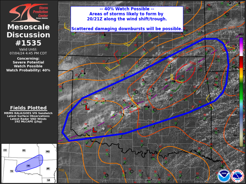
   Mesoscale Discussion 1535
   NWS Storm Prediction Center Norman OK
   0210 PM CDT Thu Jul 04 2024

   Areas affected...from southwest Oklahoma into southwest
   Missouri...and vicinity.

   Concerning...Severe potential...Watch possible

   Valid 041910Z - 042145Z

   Probability of Watch Issuance...40 percent

   SUMMARY...Scattered storms are likely to form after 20Z, with
   scattered strong to possibly severe downbursts.

   DISCUSSION...A surface trough and wind shift extend roughly from
   northwest TX across central OK and into southwest MO. Low pressure
   was noted over southwest OK, with substantial moisture convergence
   along the boundary. GPS PWAT values remain at over 1.75" over most
   of the area, even extending as far southwest as Childress, TX.

   While midlevel lapse rates are modest, low-level lapse rates are
   steepening, resulting in moderate instability overall. Towering CU
   near the boundary should form into storms over the next few hours,
   with multicellular storm mode supporting brief strong to severe
   outflows.

   ..Jewell/Gleason.. 07/04/2024

   ...Please see www.spc.noaa.gov for graphic product...

   ATTN...WFO...SGF...TSA...ICT...OUN...LUB...AMA...

   LAT...LON   35179534 34489786 34190004 34470033 35090011 35609958
               36419755 37189566 37589467 37569414 37419387 37099372
               36699368 36079380 35799395 35549428 35179534
|
|
|
Top/All Mesoscale Discussions/Forecast Products/Home |
|