2024-07-04 02:37:02
1720075642
|
|
| Mesoscale Discussion 1532 | |
| < Previous MD | |

|
|
   Mesoscale Discussion 1532
   NWS Storm Prediction Center Norman OK
   0135 AM CDT Thu Jul 04 2024

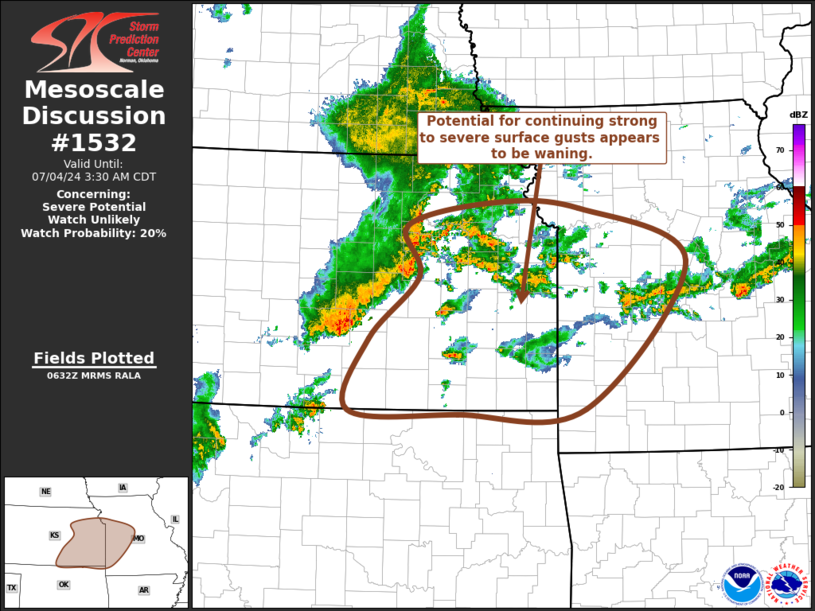
   Areas affected...eastern Kansas into western Missouri

   Concerning...Severe potential...Watch unlikely

   Valid 040635Z - 040830Z

   Probability of Watch Issuance...20 percent

   SUMMARY...Potential for strong to severe surface gusts with
   thunderstorm activity spreading toward the Missouri/Kansas state
   border (near and south of Kansas City) through 3-4 AM CDT, appears
   to be waning.  It seems unlikely a severe weather watch will be
   needed, but trends are being monitored.

   DISCUSSION...An ongoing cluster of storms developing eastward along
   the Interstate 70 corridor, and east of the Interstate 135 corridor,
   of central Kansas appears rooted within ascent associated with
   lower/mid-tropospheric warm advection.  This is generally forecast
   to continue spreading eastward ahead of a mid-level short wave
   trough progressing toward the lower Missouri Valley through
   daybreak.

   Earlier stronger convection appeared to develop strong mid-level
   rear inflow near/east of Hill City, which eventually contributed to
   a number of severe surface gusts across the Hayes/Russell through
   Salina vicinities, including up to at least 71 kt at Salina at
   0538Z.  This has recently been surging southeastward toward areas
   near and northeast of Wichita, and is now out ahead of the stronger
   convection now approaching the Missouri/Kansas state border (near
   and south of the Greater Kansas City area) through 08-08Z.

   Gusts associated with southeastward surging outflow seem likely to
   continue to wane during the next hour or two.  At the same time,
   potential for renewed strengthening of rear inflow and downward
   momentum transfer seem limited, in the presence of more modest
   lower/mid-tropospheric lapse rates across eastern Kansas into
   western Missouri.

   ..Kerr/Kerr.. 07/04/2024

   ...Please see www.spc.noaa.gov for graphic product...

   ATTN...WFO...LSX...SGF...EAX...TSA...TOP...ICT...OUN...

   LAT...LON   39179685 39449556 39389427 38739268 37009419 36959609
               36999771 37839742 38589667 39179685
|
|
|
Top/All Mesoscale Discussions/Forecast Products/Home |
|


