2024-07-03 21:56:05
1720058299
|
|
| Mesoscale Discussion 1531 | |
| < Previous MD | |

|
|
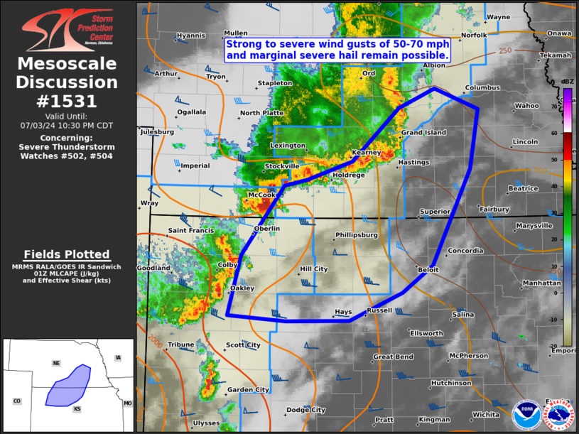
Mesoscale Discussion 1531 NWS Storm Prediction Center Norman OK 0855 PM CDT Wed Jul 03 2024 Areas affected...northwest/north-central KS and south-central NE Concerning...Severe Thunderstorm Watch 502...504... Valid 040155Z - 040330Z The severe weather threat for Severe Thunderstorm Watch 502, 504 continues. SUMMARY...Strong to severe wind gusts of 50-70 mph along with marginal hail from 0.75-1.25 inches in diameter will remain possible over the next couple hours across parts of northwest to north-central Kansas and south-central Nebraska. An additional severe thunderstorm watch farther east appears unlikely. DISCUSSION...A recent uptick in the trailing portion of a predominately non-severe QLCS occurred in far southwest NE, yielding a measured severe gust of 55 kts at the McCook ASOS. This portion of the line appears likely to merge with a more north/south-oriented cluster over northwest KS which has produced a measured strong gust of 46 kts at the Colby AWOS. The thermodynamic environment immediately downstream is still favorable for occasional intensification during the next hour or so. But towards 04-05Z, the combination of increasing MLCIN and diminishing buoyancy with eastern extent suggests the severe wind threat should wane east of north-central KS. ..Grams.. 07/04/2024 ...Please see www.spc.noaa.gov for graphic product... ATTN...WFO...OAX...TOP...ICT...GID...DDC...GLD... LAT...LON 40360005 40449972 40649905 41269835 41479780 41249715 40559728 39469786 39159831 38829909 38820002 38870087 39570068 40360005 |
|
|
Top/All Mesoscale Discussions/Forecast Products/Home |
|


