2024-07-03 18:34:04
1720046182
|
|
| Mesoscale Discussion 1526 | |
| < Previous MD | |

|
|
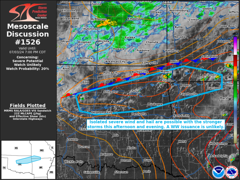
   Mesoscale Discussion 1526
   NWS Storm Prediction Center Norman OK
   0531 PM CDT Wed Jul 03 2024

   Areas affected...portions of northeastern Oklahoma into southwestern
   Missouri

   Concerning...Severe potential...Watch unlikely

   Valid 032231Z - 040000Z

   Probability of Watch Issuance...20 percent

   SUMMARY...Strong thunderstorms may develop through the remainder of
   the afternoon. A couple instances of severe wind and hail are
   possible. However, any severe threat that materializes should remain
   isolated, so a WW issuance is not expected.

   DISCUSSION...Visible satellite and MRMS mosaic radar imagery shows a
   line of cumulus congestus and associated isolated thunderstorm
   development, located along a baroclinic boundary extending from
   southwestern MO into northeast OK. These storms are developing amid
   2000 J/kg MLCAPE and 35+ kts of effective bulk shear. Straight
   hodographs with modest length are noted via regional VAD profilers,
   suggesting that multicells and perhaps transient supercells will be
   the primary modes of convection for any storms that can become
   established. Severe wind and hail are the main concerns. However,
   the severe threat should remain isolated, and a WW issuance is not
   currently anticipated.

   ..Squitieri/Hart.. 07/03/2024

   ...Please see www.spc.noaa.gov for graphic product...

   ATTN...WFO...LZK...SGF...TSA...OUN...

   LAT...LON   36279252 35979391 35619548 35559637 35479731 35569795
               36039812 36099805 36579585 36989397 36849312 36689249
               36279252
|
|
|
Top/All Mesoscale Discussions/Forecast Products/Home |
|