2024-07-03 16:59:02
1720040900
|
|
| Mesoscale Discussion 1523 | |
| < Previous MD | |

|
|
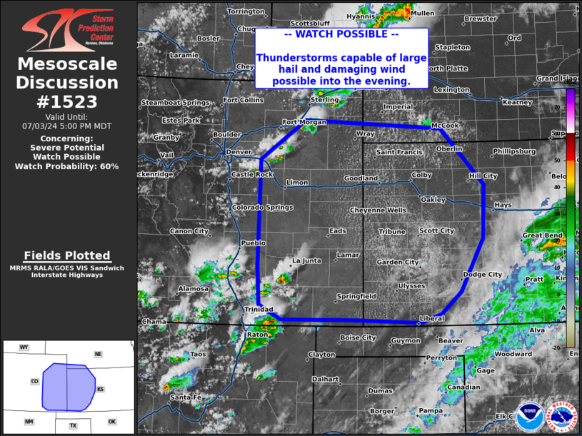
   Mesoscale Discussion 1523
   NWS Storm Prediction Center Norman OK
   0357 PM CDT Wed Jul 03 2024

   Areas affected...eastern Colorado into western Kansas

   Concerning...Severe potential...Watch possible

   Valid 032057Z - 032300Z

   Probability of Watch Issuance...60 percent

   SUMMARY...Thunderstorms capable of large hail and damaging wind to
   continue through the evening.

   DISCUSSION...Thunderstorms have developed across eastern Colorado
   this afternoon along a lee trough located in the central high
   Plains, with additional development expected through the rest of the
   afternoon and evening. Ahead of this activity, portions of eastern
   Colorado into western Kansas have destabilized with daytime heating.
   MLCAPE around 1000-2000 J/kg is observed in mesoanalysis amid deep
   layer shear of 40-50 kts. Storm mode will initially favor supercells
   with potential for large hail, damaging wind, and perhaps a tornado.
   Through the evening, cells may attempt to merge along outflow with
   risk of damaging wind increasing. A watch may be needed in the next
   couple of hours.

   ..Thornton/Gleason.. 07/03/2024

   ...Please see www.spc.noaa.gov for graphic product...

   ATTN...WFO...GID...DDC...GLD...PUB...BOU...

   LAT...LON   39710420 40370325 40220041 39299951 38429955 37540002
               37190043 37040084 37090232 37090373 37330419 37960422
               39710420
|
|
|
Top/All Mesoscale Discussions/Forecast Products/Home |
|