2024-07-02 15:26:03
1719948887
|
|
| Mesoscale Discussion 1511 | |
| < Previous MD | |

|
|
   Mesoscale Discussion 1511
   NWS Storm Prediction Center Norman OK
   0224 PM CDT Tue Jul 02 2024

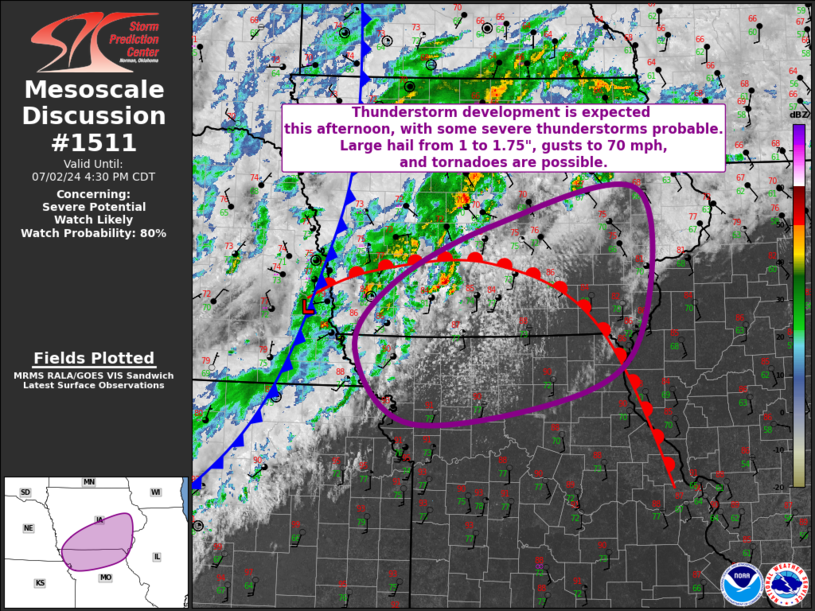
   Areas affected...Far Northeast KS...Southern IA...Northern MO

   Concerning...Severe potential...Watch likely

   Valid 021924Z - 022130Z

   Probability of Watch Issuance...80 percent

   SUMMARY...Thunderstorms are expected to develop across northern
   Missouri and southern Iowa this afternoon. Environmental conditions
   support severe thunderstorms capable of large hail from 1 to 1.75"
   and gusts to 70 mph. A few tornadoes are possible as well.

   DISCUSSION...Visible satellite imagery has shown an increasingly
   agitated cumulus field over far northwest MO and adjacent
   south-central IA. This cumulus is building within an area of
   moderate low-level convergence just to the south of a warm front
   extending eastward from the far southern IA/NE border across
   southern IA and then southeastward to the IA/MO/IL border
   intersection vicinity. Temperatures immediately south of this front
   are in the mid to upper 80s with dewpoints in the low 70s. These
   warm and moist low-level conditions are supporting strong buoyancy,
   with recent mesoanalysis estimating MLCAPE from 2000 to 2500 J/kg.
   Continued heating and low-level moisture advection could help push
   MLCAPE over 3000 J/kg over the next hour or two. Flat character to
   much of the cumulus suggest some convective inhibition likely
   remains across a majority of the region. However, recent
   mesoanalysis and modified forecast soundings suggest that only
   minimal convective inhibition remains and some of the more recent
   cumulus development appears to have a sharper character. All of
   these factors indicate that convective initiation will likely occur
   soon.

   Moderate deep-layer vertical shear is already place, evidenced by
   the 18Z TOP sounding sampling 40 kt of 0-6 km bulk shear. This
   matches the recent mesoanalysis, which is estimating 40 to 50 kt.
   This is sufficient for organized convection, including a few
   supercells if a discrete mode can be maintained. Low-level flow will
   likely be veered, but some strengthening in the 850 to 700 mb layer
   could still help elongate hodographs, supporting some tornado
   potential. This potential will be augmented by increased vorticity
   near the warm front. Some large hail from 1 to 1.75" is possible and
   water-loaded downbursts are possible as well. After an initially
   cellular mode, upscale growth into an organized convective line
   appears likely, with damaging gusts as the primary severe risk.
   Given this severe potential, a watch will likely be needed across
   portions of the area.

   ..Mosier/Gleason.. 07/02/2024

   ...Please see www.spc.noaa.gov for graphic product...

   ATTN...WFO...LSX...DVN...DMX...EAX...OAX...

   LAT...LON   39959207 39589461 40409549 41169494 41849344 42259127
               40739119 39959207
|
|
|
Top/All Mesoscale Discussions/Forecast Products/Home |
|


