2024-07-01 19:46:03
1719877888
|
|
| Mesoscale Discussion 1509 | |
| < Previous MD | |

|
|
   Mesoscale Discussion 1509
   NWS Storm Prediction Center Norman OK
   0643 PM CDT Mon Jul 01 2024

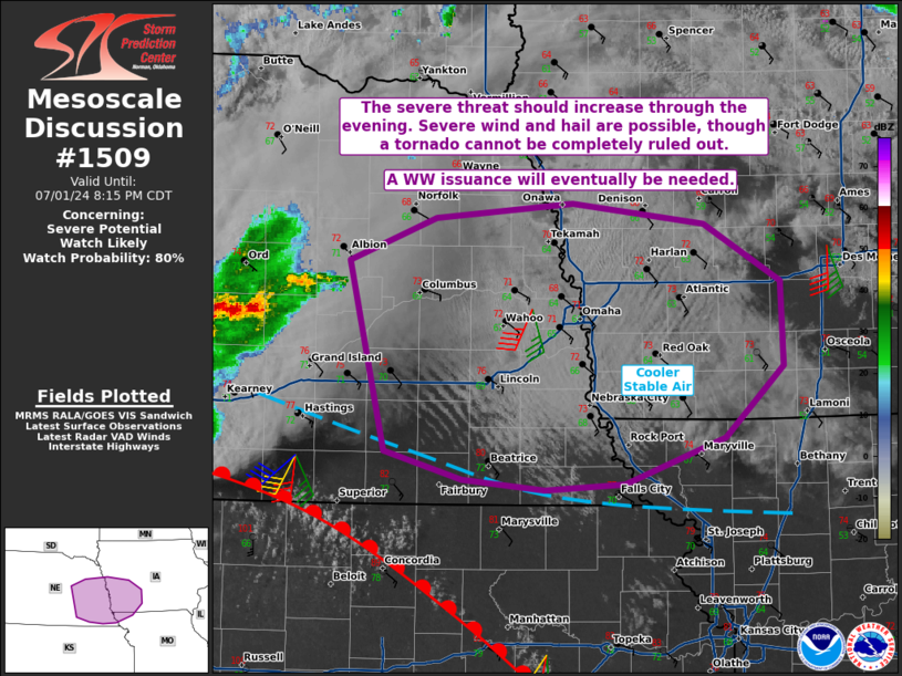
   Areas affected...portions of eastern Nebraska into western Iowa

   Concerning...Severe potential...Watch likely

   Valid 012343Z - 020115Z

   Probability of Watch Issuance...80 percent

   SUMMARY...The severe threat will gradually increase as the warm
   front approaches and the low-level airmass destabilizes through the
   evening. Severe wind and hail are the predominant threats, though a
   tornado or two could also occur. A WW issuance will eventually be
   needed.

   DISCUSSION...Several thunderstorms are progressing eastward across
   NE, including a supercell that is traversing the warm frontal zone
   with a history of brief tornadoes. The surface warm front is
   expected to continue drifting northward with time as low-level
   warm-air advection increases in tandem with the strengthening of the
   low-level jet. Initially elevated buoyancy will advect over eastern
   NE into western IA with large, curved hodographs. The stronger,
   longer-lived updrafts that form should become multicellular and
   perhaps supercellular, capable of severe wind and hail. The tornado
   potential will be largely dependent on the degree of
   surface-based/boundary-layer destabilization can materialize this
   evening. A WW issuance will eventually be needed as storms across
   central NE impinge on the eastern bounds of Tornado Watch 496.

   ..Squitieri/Smith.. 07/01/2024

   ...Please see www.spc.noaa.gov for graphic product...

   ATTN...WFO...DMX...EAX...OAX...GID...

   LAT...LON   41649799 41939721 42029599 41889483 41509414 40929412
               40459464 40149553 40099625 40169697 40369766 41649799
|
|
|
Top/All Mesoscale Discussions/Forecast Products/Home |
|


