2024-07-01 15:18:05
1719862047
|
|
| Mesoscale Discussion 1503 | |
| < Previous MD | |

|
|
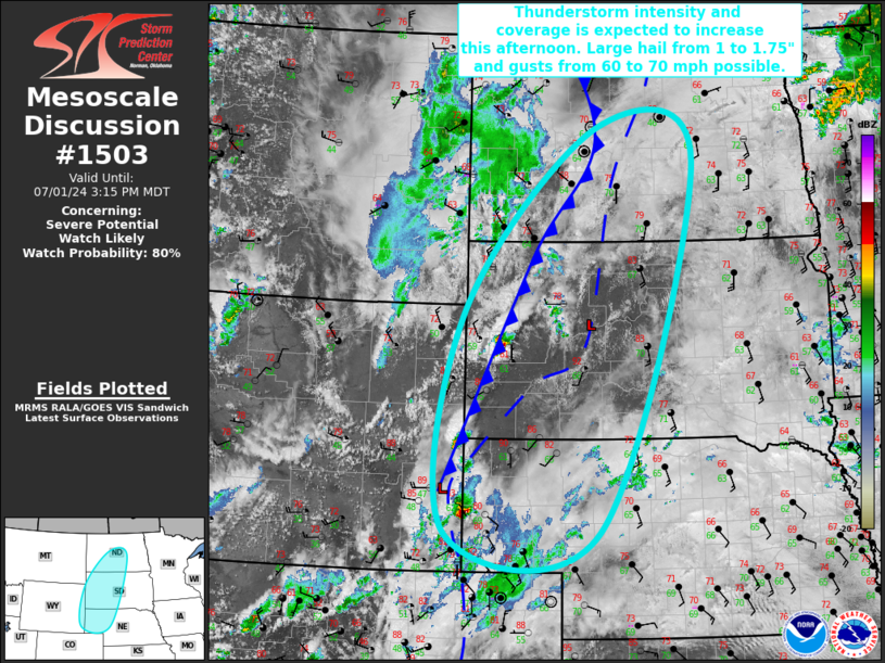
Mesoscale Discussion 1503 NWS Storm Prediction Center Norman OK 0216 PM CDT Mon Jul 01 2024 Areas affected...Far Southeastern WY...NE Panhandle...Western/Central SD...Central ND Concerning...Severe potential...Watch likely Valid 011916Z - 012115Z Probability of Watch Issuance...80 percent SUMMARY...Thunderstorm intensity and coverage is expected to increase over the next few hours from the central Dakotas into the Nebraska Panhandle and far southeast Wyoming. Some severe thunderstorms capable of 1 to 1.75" hail and gusts from 60 to 70 mph are possible. DISCUSSION...Satellite imagery shows a broad shortwave trough progressing eastward across the northern Rockies/northern High Plains. The airmass downstream from the NE Panhandle into the central Dakotas continues to destabilize amid filtered daytime heating and ample low-level moisture. Recent surface observations show upper 60s dewpoints extending northward in the vicinity of a pre-frontal trough from far southeast WY into central ND. Expectation is for scattered to numerous thunderstorm development to occur over the next few hours ahead of the approaching shortwave, both along the cold front and pre-frontal trough. A predominately linear mode is anticipated along the front, but a few supercells are possible farther east along the lee trough where the buoyancy is greater and the vertical shear vector is a bit more southwesterly/westerly. Large hail around 1.75" is the primary threat with any more cellular development. Gusts from 60 to 70 mph will be the primary threat with the more linear storms. A Severe Thunderstorm Watch will likely be needed to address this severe potential. ..Mosier/Gleason.. 07/01/2024 ...Please see www.spc.noaa.gov for graphic product... ATTN...WFO...ABR...BIS...LBF...UNR...CYS... LAT...LON 41570443 44910407 47630129 47109926 41580127 41570443 |
|
|
Top/All Mesoscale Discussions/Forecast Products/Home |
|