2024-06-30 23:39:05
1719805334
|
|
| Mesoscale Discussion 1502 | |
| < Previous MD | |

|
|
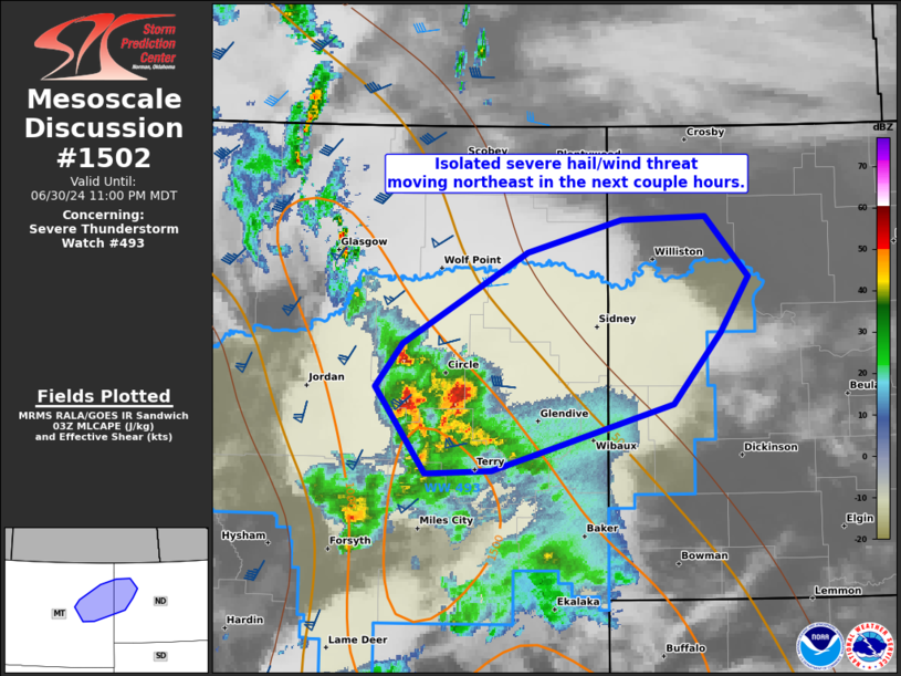
Mesoscale Discussion 1502 NWS Storm Prediction Center Norman OK 1036 PM CDT Sun Jun 30 2024 Areas affected...parts of eastern MT/western ND Concerning...Severe Thunderstorm Watch 493... Valid 010336Z - 010500Z The severe weather threat for Severe Thunderstorm Watch 493 continues. SUMMARY...An isolated severe wind/hail threat should shift across a part of east-central Montana before weakening in western North Dakota overnight. DISCUSSION...Strengthening of the low-level jet earlier this evening (the eastern periphery of which is sampled by the Bismarck VWP), yielded an increase in thunderstorm development along remnant outflow from decayed afternoon convection. Thus far, severe wind gusts up to 53 kts have been measured at Miles City, with golfball-sized hail reported in Treasure County, MT. Recently, the more intense updrafts have accelerated northeastward in east-central MT. This trend is expected to continue as MLCIN becomes more pronounced south of the I-94 corridor. The orientation of this evolution will result in storms encountering an increasingly more stable airmass in western ND. This should yield a diminishing trend to storms as they spread farther northeastward overnight. Until that time, isolated large hail and severe wind gusts will remain possible, mainly through about 06Z. ..Grams.. 07/01/2024 ...Please see www.spc.noaa.gov for graphic product... ATTN...WFO...BIS...BYZ...GGW... LAT...LON 47590599 48190480 48390391 48410310 48030270 47660296 47200341 46780515 46750577 47320626 47590599 |
|
|
Top/All Mesoscale Discussions/Forecast Products/Home |
|


