2024-06-30 14:18:06
1719771555
|
|
| Mesoscale Discussion 1490 | |
| < Previous MD | |

|
|
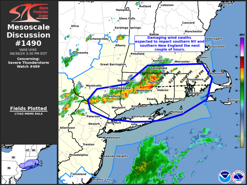
Mesoscale Discussion 1490 NWS Storm Prediction Center Norman OK 1259 PM CDT Sun Jun 30 2024 Areas affected...southern NY into southern New England Concerning...Severe Thunderstorm Watch 489... Valid 301759Z - 301930Z The severe weather threat for Severe Thunderstorm Watch 489 continues. SUMMARY...A line of intense storms will shift east across southern New England and Southern New York/portions of Long Island the next couple of hours. Swaths of wind damage will accompany this activity. DISCUSSION...A well organized bowing segment over CT will continue to shift east at around 35-40 kt the next couple of hours. This activity has a long history of producing wind damage, and this trend is expected to continue as the bow moves across CT into RI and southern MA through 4pm EDT. An area of convection to the southwest of the bow continues to become better organized from southern NY into western CT. This activity should also continue generally eastward over the next couple of hours and may impact portions of Long Island. Damaging gusts may also accompany this activity. ..Leitman.. 06/30/2024 ...Please see www.spc.noaa.gov for graphic product... ATTN...WFO...BOX...OKX...ALY...PHI... LAT...LON 42217266 42247085 41887055 41387073 41027155 40907210 40857255 40837310 40897387 41087449 41367460 41637430 41767337 42217266 |
|
|
Top/All Mesoscale Discussions/Forecast Products/Home |
|
Source link