2024-06-29 19:46:02
1719705326
|
|
| Mesoscale Discussion 1482 | |
| < Previous MD Next MD > | |

|
|
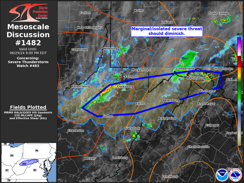
Mesoscale Discussion 1482 NWS Storm Prediction Center Norman OK 0630 PM CDT Sat Jun 29 2024 Areas affected...northern WV and the western MD Panhandle Concerning...Severe Thunderstorm Watch 483... Valid 292330Z - 300100Z The severe weather threat for Severe Thunderstorm Watch 483 continues. SUMMARY...A marginal and fairly isolated severe threat may persist through about dusk. Additional severe thunderstorm watch issuance beyond the 02Z expiration is unlikely. DISCUSSION...A lone robust updraft exists within WW 483 across north WV. This specific cell appeared to be a left-split amid a nearly unidirectional wind profile inferred between RLX/PBZ VWPs. This may have briefly produced marginally severe hail per MESH signatures, but appears to have peaked. In its wake, a stronger storm cluster over southwest OH has likewise appeared to have peaked in convective intensity. With weak low-level flow persisting to the south of both convective areas, the overall severe threat should continue on a diminishing trend, although storms should persist beyond dusk. ..Grams.. 06/29/2024 ...Please see www.spc.noaa.gov for graphic product... ATTN...WFO...LWX...PBZ...RLX... LAT...LON 39358054 39487983 39647828 39627782 39587754 39317753 38757984 38698084 38868125 39358054 |
|
|
Top/All Mesoscale Discussions/Forecast Products/Home |
|