2024-06-29 17:32:06
1719697340
|
|
| Mesoscale Discussion 1478 | |
| < Previous MD | |

|
|
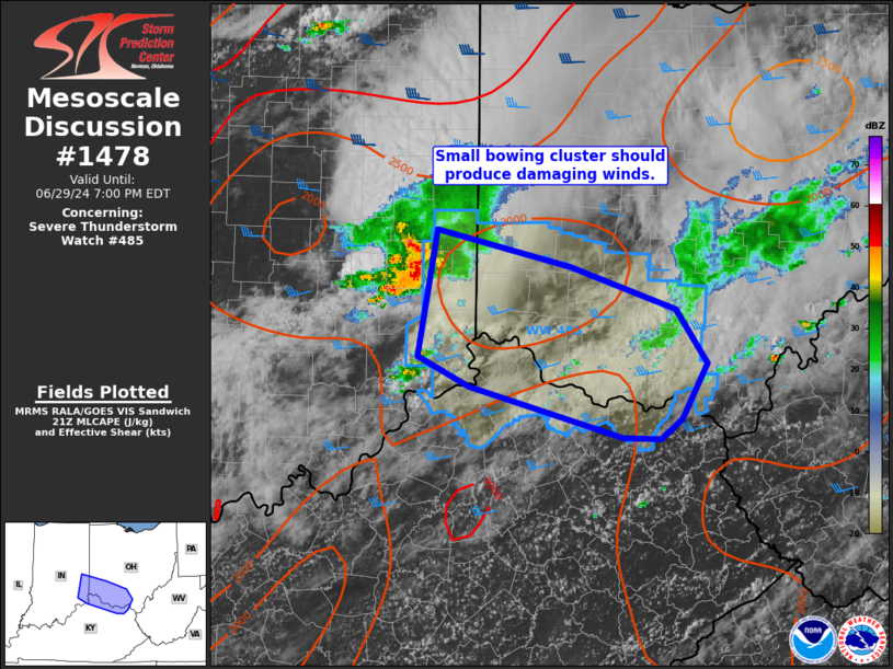
Mesoscale Discussion 1478 NWS Storm Prediction Center Norman OK 0430 PM CDT Sat Jun 29 2024 Areas affected...southeast IN...southwest IN...far northern KY Concerning...Severe Thunderstorm Watch 485... Valid 292130Z - 292300Z The severe weather threat for Severe Thunderstorm Watch 485 continues. SUMMARY...A threat for damaging wind gusts from 55-70 mph will remain probable with a small bowing cluster moving east-southeast towards the central Ohio Valley. DISCUSSION...A small bowing cluster was ongoing between the I-70 and I-74 corridors in the eastern IN. The Indianapolis VWP in the wake of this cluster continues to sample a belt of 35-50 kt mid-level westerlies which will aid in sustaining convective organization as this cluster likely tracks east-southeastward over the next few hours. Incipient Cb development is also occurring farther south closer to the OH River in southeast IN. It is plausible this may merge into the cluster across the IN/OH/KY border area and yield an overall southeast shift to convective development. This should spread across the I-75/I-71 corridors in southwest OH to northern KY. The greatest threat for damaging winds should be focused near the apex of the small bow. ..Grams.. 06/29/2024 ...Please see www.spc.noaa.gov for graphic product... ATTN...WFO...RLX...JKL...ILN... LAT...LON 39868516 39618397 39318301 38928274 38538297 38408316 38418350 38778488 38978533 39868516 |
|
|
Top/All Mesoscale Discussions/Forecast Products/Home |
|