|
|
| Mesoscale Discussion 1455 | |
| < Previous MD Next MD > | |

|
|
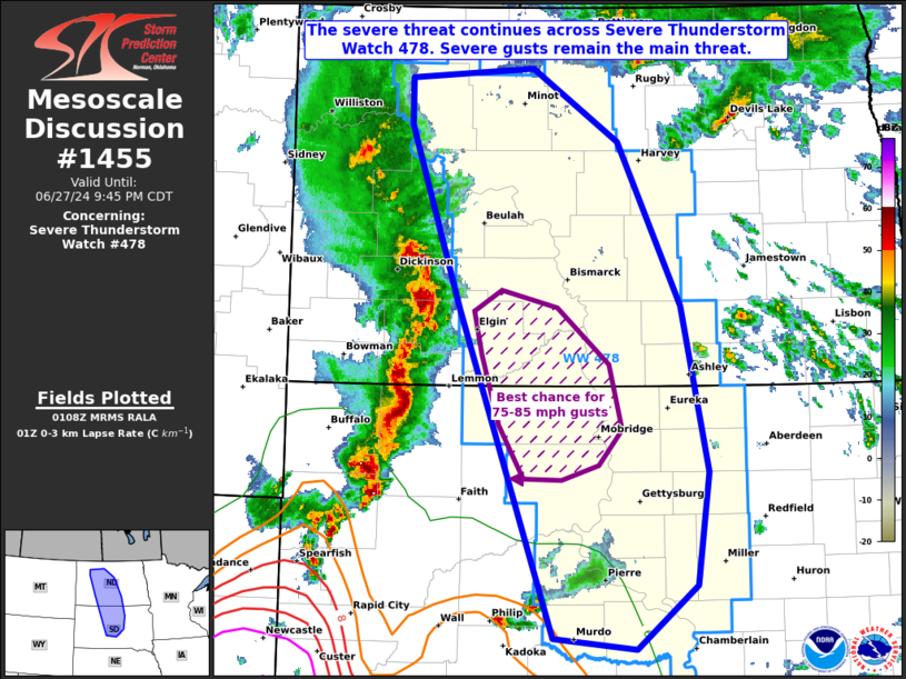
Mesoscale Discussion 1455 NWS Storm Prediction Center Norman OK 0811 PM CDT Thu Jun 27 2024 Areas affected...portions of central North Dakota into central South Dakota Concerning...Severe Thunderstorm Watch 478... Valid 280111Z - 280245Z The severe weather threat for Severe Thunderstorm Watch 478 continues. SUMMARY...The severe threat continues across Severe Thunderstorm Watch 478. Severe gusts are the main threat, though a QLCS tornado remains possible. DISCUSSION...A mature MCS with a history of several severe gusts (some of which were measured in the 80-90 mph range per surface observations) continues across western ND/SD. The most recent significant-severe gusts have occurred within mesovortices across southwestern ND, where a QLCS tornado also remains possible. However, 00Z mesoanalysis depicts 0-3 km lapse rates rapidly decreasing over ND with east extent, but with 6 C/km 0-3 km lapse rates present over a wider corridor in SD. As such, severe gust potential (including peak 75-85 mph gusts) will be greatest over southern ND into northern SD for at least a few more hours. ..Squitieri.. 06/28/2024 ...Please see www.spc.noaa.gov for graphic product... ATTN...WFO...ABR...BIS...UNR... LAT...LON 43880095 46560203 48050262 48430262 48500119 47920019 46599945 45239914 44329928 43799998 43880095 |
|
|
Top/All Mesoscale Discussions/Forecast Products/Home |
|