|
|
| Mesoscale Discussion 1449 | |
| < Previous MD Next MD > | |

|
|
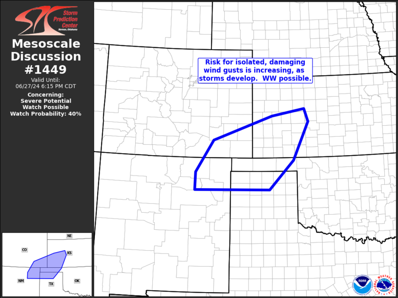
   Mesoscale Discussion 1449
   NWS Storm Prediction Center Norman OK
   0447 PM CDT Thu Jun 27 2024

   Areas affected...northeastern New Mexico...southeastern
   Colorado...southwestern Kansas...and portions of the Oklahoma/Texas
   Panhandles

   Concerning...Severe potential...Watch possible

   Valid 272147Z - 272315Z

   Probability of Watch Issuance...40 percent

   SUMMARY...Storms developing across portions of the central/southern
   High Plains region from southeastern Colorado/northeastern New
   Mexico northeastward into southwestern Kansas will pose increasing
   risk for locally severe wind gusts.  WW may be required in the next
   hour.

   DISCUSSION...Latest radar loop shows storms gradually increasing in
   coverage from northeastern New Mexico and adjacent southeastern
   Colorado, to near of KTQX (Scott City, KS).  The storms are
   occurring in a hot/deeply mixed boundary layer, where modest CAPE
   above the LCL is supporting a few stronger updrafts.  The
   development appears to be occurring in part due to response of the
   environment to a very subtle/mid-level disturbance moving eastward
   across southern Colorado at this time.

   While a more unstable airmass -- and thus potential for more robust
   convection -- exists farther north, into northwestern Kansas and
   points north, the deep/dry boundary layer will promote potential for
   evaporatively enhanced downdrafts, and associated potential for
   severe-caliber gusts locally.  We will continue to monitor this
   region in the short term, for signs that risk may increase in
   coverage, which could support the need to consider WW issuance.

   ..Goss/Smith.. 06/27/2024

   ...Please see www.spc.noaa.gov for graphic product...

   ATTN...WFO...DDC...GLD...AMA...PUB...ABQ...

   LAT...LON   36450465 37650383 38540113 38819962 38329944 36900015
               35810125 35800467 36450465
|
|
|
Top/All Mesoscale Discussions/Forecast Products/Home |
|
Source link