|
|
| Mesoscale Discussion 1430 | |
| < Previous MD Next MD > | |

|
|
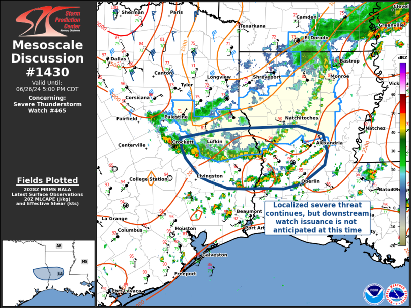
Mesoscale Discussion 1430 NWS Storm Prediction Center Norman OK 0331 PM CDT Wed Jun 26 2024 Areas affected...Southeast Texas into west-central Louisiana Concerning...Severe Thunderstorm Watch 465... Valid 262031Z - 262200Z The severe weather threat for Severe Thunderstorm Watch 465 continues. SUMMARY...A convective line moving south across East TX into West-Central LA will continue to move south and weaken as it exits the WW area. While additional convective development is ongoing ahead of the line, additional downstream WW issuance is not expected due an anticipated lack of convective organization. DISCUSSION...A bowing line of thunderstorms is exiting the watch area into West-Central LA and East TX. Radar trends indicate the overall coverage and intensity of convection is weakening, and the severe threat both ahead and behind the line will decrease this afternoon... though isolated severe wind gusts may be possible in the short term. Further south, daytime airmass thunderstorms have developed in West-Central LA, but remain unorganized with the absence of supportive deep-layer vertical shear. Given current convective trends, downstream weather watch issuance is not expected. ..Halbert/Weinman.. 06/26/2024 ...Please see www.spc.noaa.gov for graphic product... ATTN...WFO...LCH...SHV...HGX... LAT...LON 31609445 31649405 31669323 31689279 31529227 31219217 30979224 30789250 30649272 30549309 30569355 30549389 30569427 30679465 30769485 31089515 31089515 31259523 31469526 31609445 |
|
|
Top/All Mesoscale Discussions/Forecast Products/Home |
|