|
|
| Mesoscale Discussion 1425 | |
| < Previous MD | |

|
|
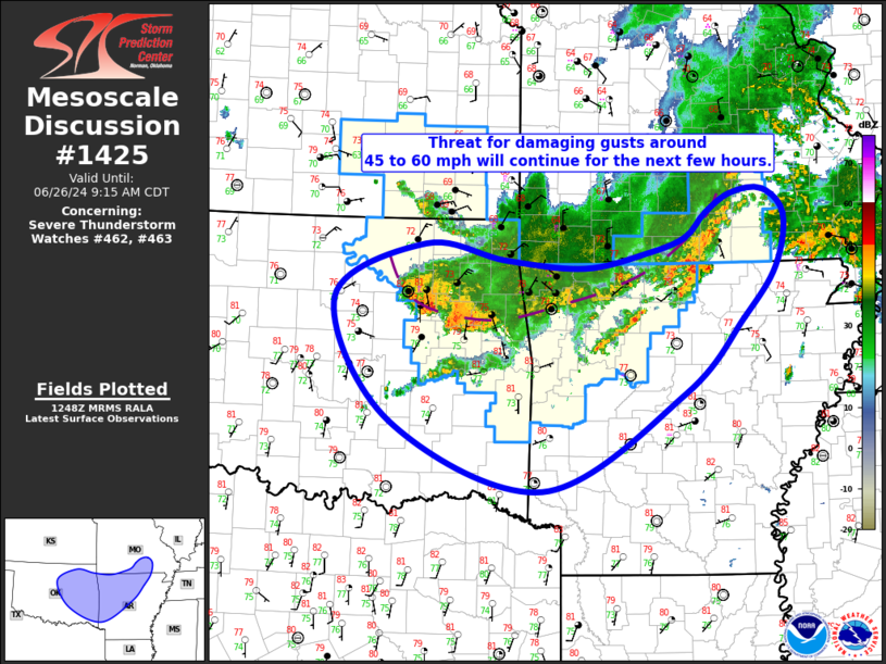
Mesoscale Discussion 1425 NWS Storm Prediction Center Norman OK 0750 AM CDT Wed Jun 26 2024 Areas affected...Eastern/Central OK...Northern/Central AR...South-Central MO Concerning...Severe Thunderstorm Watch 462...463... Valid 261250Z - 261415Z The severe weather threat for Severe Thunderstorm Watch 462, 463 continues. SUMMARY...Threat for damaging gusts, generally from 45 to 60 mph, is expected to continue. A downstream watch may eventually be needed later this morning if the line is able to reintensify. DISCUSSION...The ongoing convective line has lost some of its structure over the past hour or so as the outflow surges southward. Recent SGF VAD sampled the rear-inflow jet, which appears to have lost strength in the last hour as well. These observations are evidence of a decaying MCS, although XNA did gust to 46 kt as the line came through around 12Z. Correspondingly, damaging gusts will remain possible across northwest/north-central AR and south-central MO as the outflow continues progressing southward/southeastward. In contrast, thunderstorms have been able to maintain their intensity within western portions of the convective line moving across northeast OK. Gusts from 45 to 60 mph have been observed as this outflow surges southwestward. This trend is expected to continue for the next hour or two, with the gust front eventually surging ahead of the deeper convection as it enters central OK. Some intensification of this line is possible later this morning as the very moist airmass destabilizes quickly under modest heating. A downstream watch may be needed if trends indicate this intensification is underway. ..Mosier.. 06/26/2024 ...Please see www.spc.noaa.gov for graphic product... ATTN...WFO...PAH...LSX...LZK...SGF...SHV...TSA...OUN... LAT...LON 36099716 36729590 36549479 36459370 36629282 36799231 37069202 37289166 37319123 37039093 36459105 35889151 35029234 33949429 34729637 36099716 |
|
|
Top/All Mesoscale Discussions/Forecast Products/Home |
|