|
|
| Mesoscale Discussion 1413 | |
| < Previous MD Next MD > | |

|
|
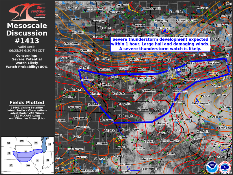
   Mesoscale Discussion 1413
   NWS Storm Prediction Center Norman OK
   0454 PM CDT Tue Jun 25 2024

   Areas affected...Southern Iowa...far northern Illinois...far eastern
   NE...and far northern Missouri

   Concerning...Severe potential...Watch likely

   Valid 252154Z - 252330Z

   Probability of Watch Issuance...80 percent

   SUMMARY...Scattered thunderstorms will continue to develop along a
   cold front across the southern half of IA, far northern IL, and
   eventually move into northern MO this evening. Large hail up to
   1.5-2.5" in diameter and damaging wind gusts near 60-70 mph will be
   possible as the thunderstorms mature early this evening.

   DISCUSSION...Diurnal heating ahead of a cold front combined with a
   very moist boundary layer beneath steep mid-level lapse rates has
   contributed to a moderately to extremely unstable air mass this
   afternoon. Surface convergence along the front has already lead to
   thunderstorm initiation. Subtle height falls over the next several
   hours associated with an upper trough to the north will continue to
   aid in scattered thunderstorm development. Although mid to
   upper-level flow is modest, sufficient deep layer effective shear
   around 30-35 kt will support storm organization and some discrete
   supercell potential before storms interact further south later this
   evening. Any stronger thunderstorms across northern IL may be short
   lived as they encounter a less favorable air mass/cold pool from an
   earlier convective complex to the south and east.

   Large hail will initially accompany the more robust updrafts through
   early evening. Thereafter, storm mergers and clusters with deepening
   outflow may result in a favored area of damaging wind gusts across
   far southern IA and northern MO. A severe thunderstorm watch will be
   needed soon.

   ..Barnes/Gleason.. 06/25/2024

   ...Please see www.spc.noaa.gov for graphic product...

   ATTN...WFO...LOT...MKX...LSX...DVN...DMX...EAX...OAX...TOP...

   LAT...LON   41808763 42548782 42488986 42429030 42259072 42259072
               42089149 41919232 41909323 41879475 41789546 42039743
               41269713 40709649 39519505 39569269 40029164 40919098
               41498977 41668839 41808763
|
|
|
Top/All Mesoscale Discussions/Forecast Products/Home |
|