|
|
| Mesoscale Discussion 1408 | |
| < Previous MD | |

|
|
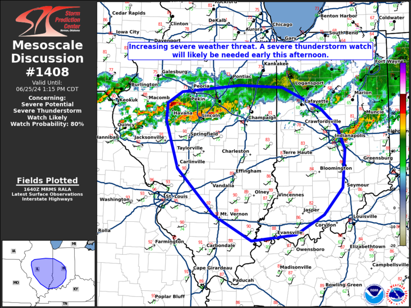
   Mesoscale Discussion 1408
   NWS Storm Prediction Center Norman OK
   1143 AM CDT Tue Jun 25 2024

   Areas affected...central/southern Illinois into western Indiana

   Concerning...Severe potential...Severe Thunderstorm Watch likely

   Valid 251643Z - 251815Z

   Probability of Watch Issuance...80 percent

   SUMMARY...There may be an increased severe weather threat early this
   afternoon across central/southern Illinois and far western Indiana

   DISCUSSION...Some increase in convective coverage has started across
   the western portion of a remnant MCS across central/west-central
   Illinois. Ahead of this activity, clear skies have permitted strong
   heating with dewpoints in the low to mid 70s. This yields over 3000
   J/kg MLCAPE. SPC mesoanalysis shows decreasing inhibition across
   Illinois with an increasing cumulus field across Missouri.
   Therefore, with some additional heating, expect inhibition to erode
   and some increasing intensity of ongoing storms across central
   Illinois. The hot and moist airmass should support a damaging wind
   threat as this cluster of storms moves southeast through the
   afternoon.

   The threat should persist to the eastern extent of the greater
   heating/low-level moisture advection which is forecast somewhere
   between Terre Haute and Indianapolis and eventually approach the
   Ohio River by evening.

   ..Bentley/Hart.. 06/25/2024

   ...Please see www.spc.noaa.gov for graphic product...

   ATTN...WFO...LMK...IWX...IND...PAH...LOT...ILX...LSX...

   LAT...LON   40788842 40748739 40348646 40008608 39578588 38868596
               38368640 37988709 37878813 38348902 39228991 40119019
               40439017 40648982 40788842
|
|
|
Top/All Mesoscale Discussions/Forecast Products/Home |
|