|
|
| Mesoscale Discussion 1398 | |
| < Previous MD | |

|
|
Mesoscale Discussion 1398
NWS Storm Prediction Center Norman OK
0701 PM CDT Mon Jun 24 2024
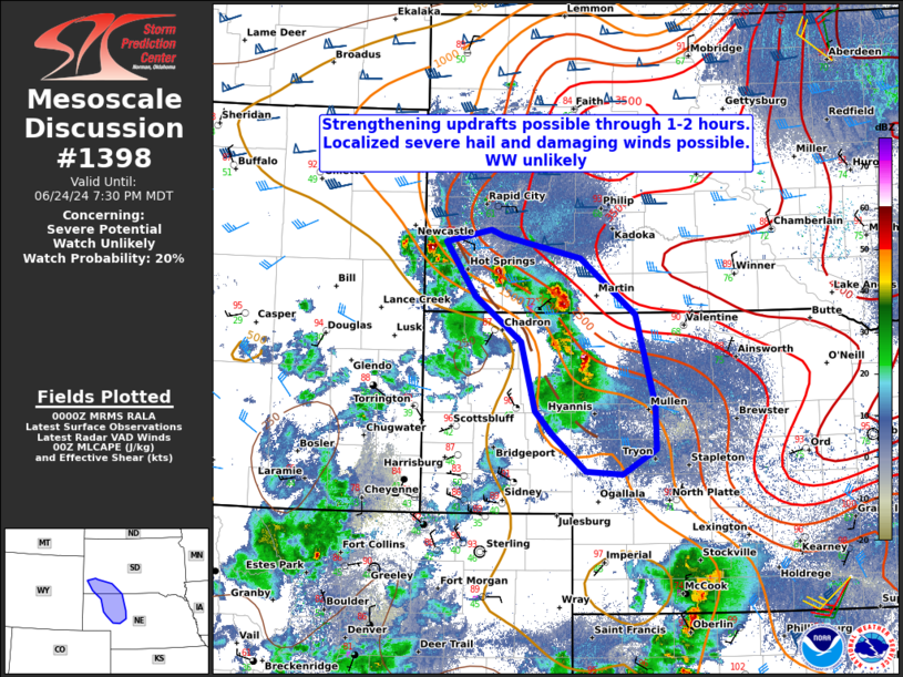
Areas affected...Far southwestern South Dakota and northwestern NE
Concerning...Severe potential...Watch unlikely
Valid 250001Z - 250130Z
Probability of Watch Issuance...20 percent
SUMMARY...Thunderstorm intensification will be possible over the
next couple of hours across portions of far southwestern SD and
northwestern NE. Isolated hail up to 1.00 to 1.75" in diameter and
severe wind gusts near 60-70 mph will be possible with the more
robust updrafts.
DISCUSSION...Both recent satellite and radar imagery indicate
updraft intensification is occurring with thunderstorms along a
surface trough extending northwest to southeast across the higher
terrain. This is also where a mid to upper-level thermal trough
exits, coincident with stronger flow aloft. Deep layer effective
shear around 35-45 kt will continue to support some updraft
organization through this evening. In addition, downstream
observations/objective surface analysis suggest these thunderstorms
will move into a more buoyant air mass, although CINH does quickly
increase further east across much of central NE/SD.
The main threat through this evening will likely be severe wind
gusts, considering large surface temperature-dewpoint
spreads/inverted V profiles, especially with merging thunderstorms
and deepening cold pools. Given the expected small area of severe
weather concern, weak forcing aloft, and loss of diurnal heating, a
WW appears unlikely at this time.
..Barnes/Gleason.. 06/25/2024
...Please see www.spc.noaa.gov for graphic product...
ATTN...WFO...LBF...UNR...CYS...
LAT...LON 43760299 43820314 43700376 43150335 42700273 42010254
41780232 41410187 41390137 41640092 42070093 42970119
43540194 43760299
|
|
|
Top/All Mesoscale Discussions/Forecast Products/Home |
|