|
|
| Mesoscale Discussion 1392 | |
| < Previous MD | |

|
|
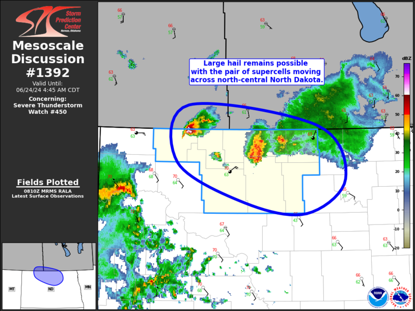
Mesoscale Discussion 1392 NWS Storm Prediction Center Norman OK 0313 AM CDT Mon Jun 24 2024 Areas affected...North-Central North Dakota Concerning...Severe Thunderstorm Watch 450... Valid 240813Z - 240945Z The severe weather threat for Severe Thunderstorm Watch 450 continues. SUMMARY...Large hail remains possible with the pair of supercells moving southeastward across north-central North Dakota. DISCUSSION...Elevated supercells continue to progress gradually southeastward across north-central North Dakota. Current storm motion with the storm over Bottineau County is around 35 kt. The storm farther west just crossing the international border is moving a bit slower, with its motion estimated at closer to 30 kt. Both of these supercells remain organized and intense, with recent MESH indicating severe hail (particularly with the westernmost cell). The lead/easternmost cell may begin weakening soon as it moves into a less buoyant airmass, although the organized character of this cell may allow it to persist farther east into greater stability than would usually be expected. The westernmost cell should be able to maintain it intensity for at least the next hour or so before it too begins to weaken. Large hail will remain possible with these storms, particularly the westernmost cell, for the next hour or two. Given the forecast weakening of these storms with eastern extent, a downstream watch is not currently anticipated, but convective trends will still be monitored closely. ..Mosier.. 06/24/2024 ...Please see www.spc.noaa.gov for graphic product... ATTN...WFO...FGF...BIS... LAT...LON 49320220 49049952 48319896 47849977 47980102 48540242 49320220 |
|
|
Top/All Mesoscale Discussions/Forecast Products/Home |
|