|
|
| Mesoscale Discussion 1382 | |
| < Previous MD | |

|
|
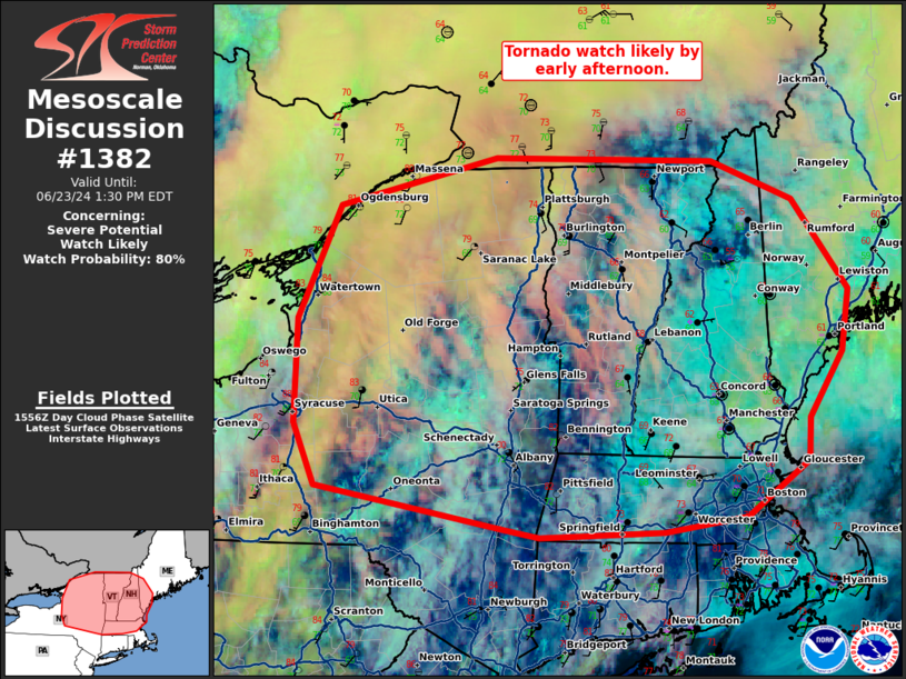
   Mesoscale Discussion 1382
   NWS Storm Prediction Center Norman OK
   1101 AM CDT Sun Jun 23 2024

   Areas affected...eastern New York...much of Vermont...and western
   Massachusetts.

   Concerning...Severe potential...Watch likely

   Valid 231601Z - 231730Z

   Probability of Watch Issuance...80 percent

   SUMMARY...A tornado watch is likely by early afternoon.

   DISCUSSION...A mid-level jet streak can be seen on water vapor
   crossing southern Ontario late this morning. As this spreads east
   through the afternoon, expect thunderstorm development along a
   pre-frontal trough, which is currently crossing Lake Ontario. A very
   moist airmass is present across eastern New York with upper 60s to
   low 70s dewpoints. In addition, some heating has occurred between
   broken cloudcover with temperatures now in the upper 70s to low 80s.
   Some additional heating, combined with cooling temperatures aloft,
   should combine to increase MLCAPE from around 500 J/kg as of 15Z to
   around 1200-1500 J/kg by 17-18Z. This instability combined with a
   favorable supercell wind profile (45-50 knots of 0-6km shear per TYX
   VWP) should result in severe storms by early to mid afternoon. Some
   hail is possible given supercell storm mode, but the warm lower
   troposphere (14kft freezing temps) may limit the hail threat
   somewhat. The greater threat is expected to be damaging wind gusts
   and a few tornadoes. Veered surface flow is the primary mitigating
   factor to a greater/more intense tornado threat given the supercell
   storm mode and 170 m2/s2 0-1 SRH (per TYX VWP). However, despite the
   somewhat veered surface flow, the low-level jet is expected to
   strengthen through the afternoon/evening which will support the
   threat.

   A tornado watch will likely be issued by 17Z.

   ..Bentley/Hart.. 06/23/2024

   ...Please see www.spc.noaa.gov for graphic product...

   ATTN...WFO...GYX...BOX...BTV...ALY...BGM...BUF...

   LAT...LON   42467589 42967612 43787610 44687566 45077395 45047157
               44747069 44027010 43537018 43017053 42667056 42227123
               42117211 42077346 42137382 42467589
|
|
|
Top/All Mesoscale Discussions/Forecast Products/Home |
|