|
|
| Mesoscale Discussion 1369 | |
| < Previous MD | |

|
|
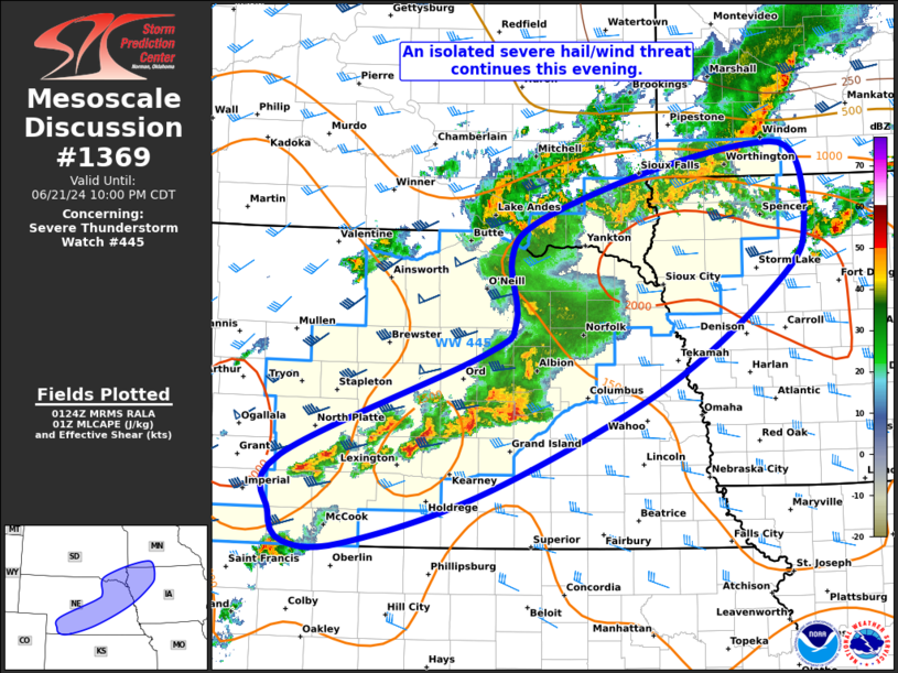
Mesoscale Discussion 1369 NWS Storm Prediction Center Norman OK 0825 PM CDT Fri Jun 21 2024 Areas affected...Parts of NE into far southeast SD...northwest IA...and far southwest MN Concerning...Severe Thunderstorm Watch 445... Valid 220125Z - 220300Z The severe weather threat for Severe Thunderstorm Watch 445 continues. SUMMARY...An isolated severe hail/wind threat continues this evening. DISCUSSION...Training cells are ongoing early this evening across south-central into eastern NE along and south of a front. The downstream 00Z sounding from OAX shows generally poor mid-level lapse rates, with a long/skinny MLCAPE profile. Still, enough low-level and deep-layer shear remains present to support organized convection, including the potential for supercells. Any thunderstorm which can remain at least semi-discrete should have some hail threat, even with the poor lapse rates aloft and associated warm mid-level temperatures. An isolated threat for severe/damaging winds may also continue, especially if thunderstorms can congeal into a small bowing cluster this evening in tandem with a gradually strengthening low-level jet. The overall tornado threat may be tempered by continued messy storm modes, although low-level shear should gradually increase this evening. Depending on convective trends, a local extension in area for Severe Thunderstorm Watch 445 may be warranted across parts of central/eastern NE. ..Gleason.. 06/22/2024 ...Please see www.spc.noaa.gov for graphic product... ATTN...WFO...MPX...DMX...FSD...OAX...GID...LBF...GLD... LAT...LON 40850119 41829868 42139825 42749832 43089800 43539667 43809530 43719471 43079458 42569486 41539634 40529860 40020038 40030113 40310131 40850119 |
|
|
Top/All Mesoscale Discussions/Forecast Products/Home |
|