|
|
| Mesoscale Discussion 1366 | |
| < Previous MD Next MD > | |

|
|
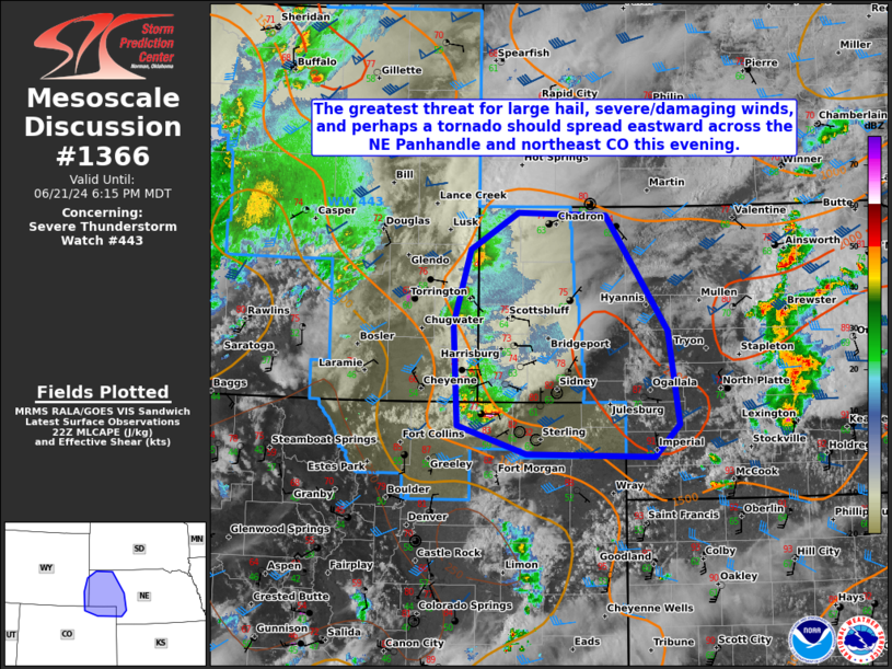
Mesoscale Discussion 1366 NWS Storm Prediction Center Norman OK 0540 PM CDT Fri Jun 21 2024 Areas affected...Parts of far eastern WY...northeast CO...and the NE Panhandle Concerning...Severe Thunderstorm Watch 443... Valid 212240Z - 220015Z The severe weather threat for Severe Thunderstorm Watch 443 continues. SUMMARY...The greatest threat for large hail, severe/damaging winds, and perhaps a tornado should spread eastward this evening over the Nebraska Panhandle and northeast Colorado. DISCUSSION...Weak low-level upslope flow is aiding widely spaced supercells across far eastern WY into northeast CO and the western NE Panhandle early this evening. Surface dewpoints and low-level moisture increase with eastward extent across these areas based on latest observations, with greater instability also being estimated by recent mesoanalysis. Strong deep-layer shear should continue to support a supercell mode in the short term, with large to isolated very large hail around 1.5-2.5 inches in diameter possible. Severe/damaging downdraft winds around 60-70 mph may also occur, especially where low-level lapse rates have become steepened with daytime heating. The southern supercell in northeast CO is the strongest storm across this region at the moment. It should have access to an unimpeded low-level moisture feed, and will likely maintain its intensity in the short term. A brief tornado may also occur this evening, particularly if supercells can be maintained farther east into the NE Panhandle where greater low-level moisture/lower LCLs are present. Based on latest observational trends, Severe Thunderstorm Watch 443 has been locally extended in area to include more of the western NE Panhandle and northeast CO. ..Gleason.. 06/21/2024 ...Please see www.spc.noaa.gov for graphic product... ATTN...WFO...LBF...BOU...CYS... LAT...LON 40760432 41790439 42560416 42930351 42900230 41720146 40770131 40430165 40460339 40760432 |
|
|
Top/All Mesoscale Discussions/Forecast Products/Home |
|