|
|
| Mesoscale Discussion 1367 | |
| < Previous MD Next MD > | |

|
|
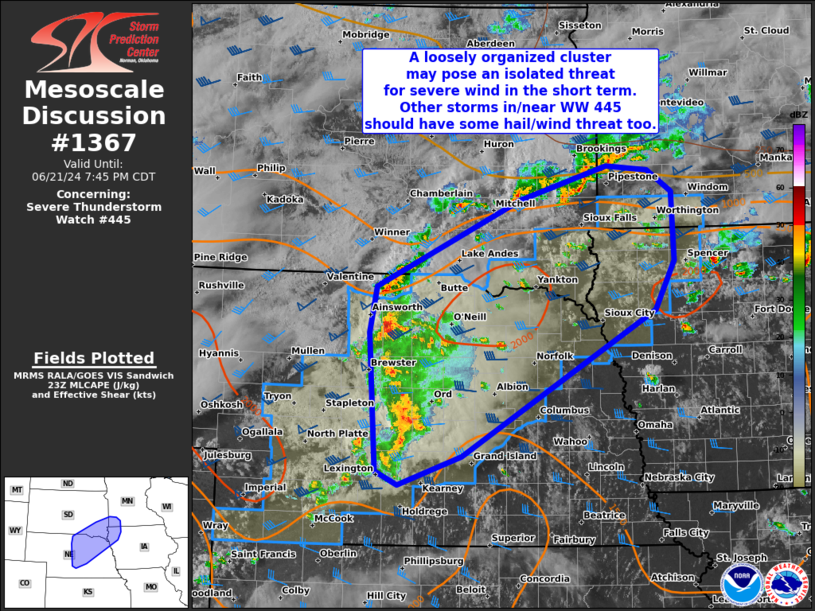
Mesoscale Discussion 1367 NWS Storm Prediction Center Norman OK 0618 PM CDT Fri Jun 21 2024 Areas affected...Parts of central/eastern NE into southeast SD...northwest IA...and southwest MN Concerning...Severe Thunderstorm Watch 445... Valid 212318Z - 220045Z The severe weather threat for Severe Thunderstorm Watch 445 continues. SUMMARY...A loosely organized cluster of thunderstorms in central/northeast Nebraska may pose an isolated threat for severe wind in the short term. Other strong to severe thunderstorms in and near Severe Thunderstorm Watch 445 should have some hail/wind threat as well. DISCUSSION...Loosely organized convection is ongoing early this evening across central into northeast NE. Although this activity is occurring in a favorable thermodynamic and kinematic environment along/near a surface front, it has struggled to intensify/consolidate thus far. There still appears to be some chance for this cluster to become more organized this evening as a modest south-southwesterly low-level jet gradually strengthens over the central Plains and mid MO Valley. If further strengthening of this activity can occur, then severe/damaging winds up to 60-70 mph would likely be the main threat as these thunderstorms spread generally east-northeastward this evening. Other, more cellular thunderstorms are ongoing across southeast SD to the north of the front. Isolated hail and strong to locally severe winds may occur with this convection as well. The tornado threat remains less clear owing to messy storm modes. Still, some increase in low-level shear is anticipated this evening, and any persistent supercell along/near the surface front could pose some threat for a tornado. ..Gleason.. 06/21/2024 ...Please see www.spc.noaa.gov for graphic product... ATTN...WFO...FSD...OAX...GID...LBF... LAT...LON 40819975 42359986 42869975 43819761 44189632 44149570 43899533 43139531 42609560 40989847 40679941 40819975 |
|
|
Top/All Mesoscale Discussions/Forecast Products/Home |
|