|
|
| Mesoscale Discussion 1364 | |
| < Previous MD Next MD > | |

|
|
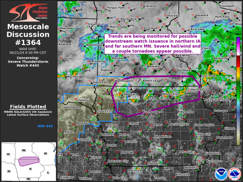
Mesoscale Discussion 1364 NWS Storm Prediction Center Norman OK 0458 PM CDT Fri Jun 21 2024 Areas affected...Parts of northern IA and southern MN Concerning...Severe Thunderstorm Watch 445... Valid 212158Z - 212330Z The severe weather threat for Severe Thunderstorm Watch 445 continues. SUMMARY...Trends are being monitored for possible downstream watch issuance in northern Iowa and perhaps far southern Minnesota. At least isolated severe hail/damaging winds and a couple tornadoes all appear possible. DISCUSSION...A supercell which has recently exhibited some low-level rotation is ongoing across northwest IA, generally along/near a surface front. Other strong to severe convection is ongoing farther east across northern IA along this boundary. This activity is likely being aided by modest warm advection associated with a weak southwesterly low-level jet over the central Plains and mid MO Valley. Although mid-level flow is not overly strong per recent mesoanalysis estimates, sufficient veering/strengthening of the winds through mid levels (in recent VWPs from KFSD) is supporting around 30-45 kt of deep-layer shear. A mix of multicells and supercells will remain possible as convection spreads slowly eastward along/near the front across northern IA over the next several hours. At least isolated severe hail around 1-2 inches in diameter and damaging winds generally 55-70 mph should be the main threats with this activity in the short term. The threat for severe winds may increase this evening if a small bowing cluster can consolidate along the front. Low-level shear/winds remain somewhat weak at the moment, but a couple of tornadoes may still occur with any sustained, surface-based supercell. Observational trends will be closely monitored for possible downstream watch issuance into northern IA and vicinity. ..Gleason/Edwards.. 06/21/2024 ...Please see www.spc.noaa.gov for graphic product... ATTN...WFO...ARX...MPX...DMX...FSD... LAT...LON 43319573 43669546 43869466 43889257 43869166 43539129 43009136 42869244 42569401 42389497 42579543 43319573 |
|
|
Top/All Mesoscale Discussions/Forecast Products/Home |
|