|
|
| Mesoscale Discussion 1360 | |
| < Previous MD | |

|
|
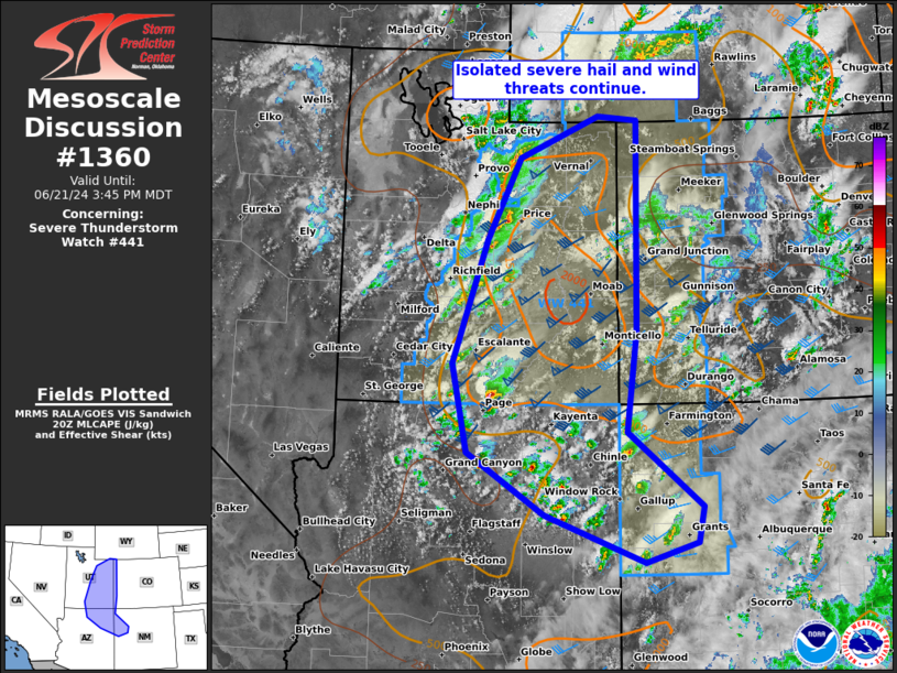
Mesoscale Discussion 1360 NWS Storm Prediction Center Norman OK 0311 PM CDT Fri Jun 21 2024 Areas affected...the Four Corners Area and eastern UT vicinity Concerning...Severe Thunderstorm Watch 441... Valid 212011Z - 212145Z The severe weather threat for Severe Thunderstorm Watch 441 continues. SUMMARY...An isolated severe hail and wind threat should continue for the next several hours as single cells and a few supercells spread slowly east-northeastward, mainly affecting the eastern Utah to Four Corners Area. DISCUSSION...Scattered to numerous thunderstorms are ongoing across the eastern Great Basin to southern/central Rockies region. The most intense storm has been a persistent slow-moving supercell along the AZ/UT border area near Page. Significant severe hail from 2-2.5 inches in diameter and even a brief tornado will be possible as this storm moves along the Lake Powell to Glen Canyon vicinity over the next couple hours. A few additional supercells should develop over eastern UT into the Four Corners vicinity amid MLCAPE of 1000-1500 J/kg and effective bulk shear of 40-50 kts. Convection across west-central CO in the Grand Junction vicinity may tend to struggle owing to the limit period of heating between morning convection and renewed development this afternoon. ..Grams.. 06/21/2024 ...Please see www.spc.noaa.gov for graphic product... ATTN...WFO...ABQ...RIW...GJT...FGZ...SLC... LAT...LON 36600889 35540758 35020768 34750859 35421036 36311174 37571201 39321139 40491080 41080939 41020868 38020872 36600889 |
|
|
Top/All Mesoscale Discussions/Forecast Products/Home |
|