|
|
| Mesoscale Discussion 1353 | |
| < Previous MD Next MD > | |

|
|
Mesoscale Discussion 1353
NWS Storm Prediction Center Norman OK
1210 PM CDT Fri Jun 21 2024
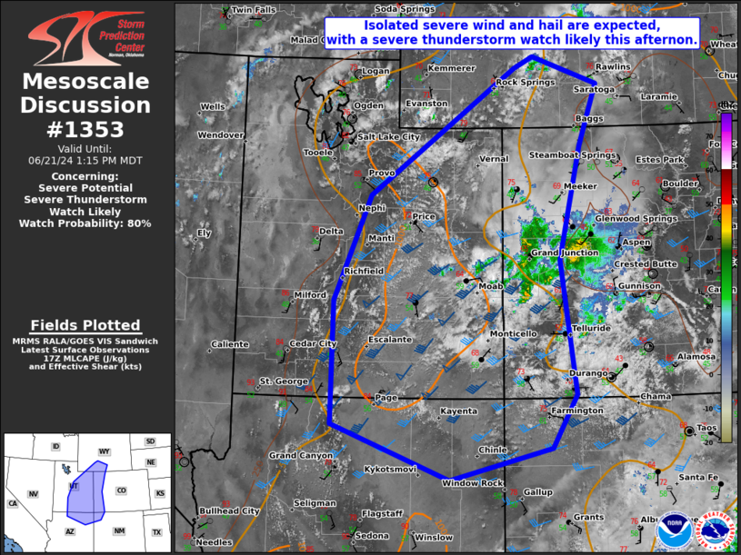
Areas affected...the Four Corners area to far southern WY
Concerning...Severe potential...Severe Thunderstorm Watch likely
Valid 211710Z - 211915Z
Probability of Watch Issuance...80 percent
SUMMARY...Isolated large hail and severe wind gusts are expected
this afternoon as scattered thunderstorms develop off the higher
terrain of the eastern Utah/northeast Arizona vicinity and spread
east-northeast. A severe thunderstorm watch will likely be issued
for parts of the region by 18-19Z.
DISCUSSION...Morning convection has finally weakened but has
maintained a plume of cloudiness that is limiting surface-based
destabilization over parts of western CO. Surrounding this remnant
convection, destabilization is well underway northeast of the
Mogollon Rim to the higher terrain of central UT. Incipient
thunderstorm development is occurring over the higher terrain and
will likely increase in coverage through the afternoon as a minor
shortwave trough over NV shifts east-northeast.
Relatively buoyant thermodynamic profiles are expected as MLCAPE
increases to 1000-1500 J/kg at peak heating. Substantial speed shear
within the deep-layer southwesterly flow regime should yield an
elongated hodograph, favorable for splitting supercell structures.
Large hail to around 2 inches in diameter will be possible, although
potential for greater magnitudes may be tempered by relatively warm
upper-level temperatures. The steepening low-level lapse rate
environment will support potential for severe wind gusts of 55-70
mph, but with more cellular coverage this threat may tend to remain
isolated.
..Grams/Hart.. 06/21/2024
...Please see www.spc.noaa.gov for graphic product...
ATTN...WFO...CYS...ABQ...RIW...GJT...FGZ...SLC...
LAT...LON 41640721 40720755 39030796 37040769 36260815 35791005
36601224 38431223 40001154 41880881 42040844 41640721
|
|
|
Top/All Mesoscale Discussions/Forecast Products/Home |
|