|
|
| Mesoscale Discussion 1350 | |
| < Previous MD | |

|
|
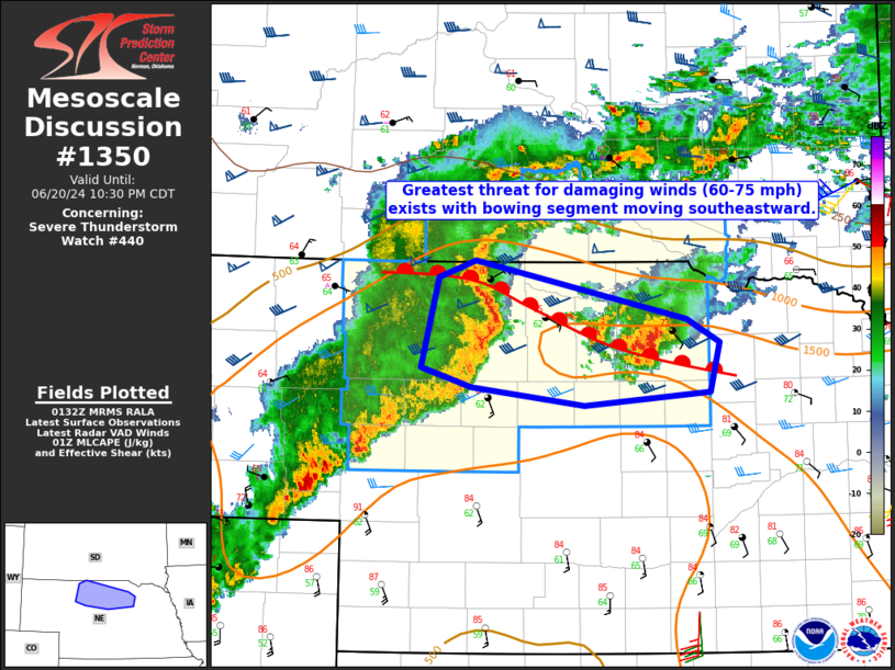
Mesoscale Discussion 1350 NWS Storm Prediction Center Norman OK 0835 PM CDT Thu Jun 20 2024 Areas affected...North-central Nebraska Concerning...Severe Thunderstorm Watch 440... Valid 210135Z - 210330Z The severe weather threat for Severe Thunderstorm Watch 440 continues. SUMMARY...The threat of severe gusts will continue this evening with a organized bowing segment in Cherry County moving south-southeast along the warm front. Gusts of 60-75 mph appear possible. DISCUSSION...A bowing segment has developed within Cherry County as a result of linear convection interacting with a supercell. This portion of the convective line is also moving along the warm front in northern Nebraska. With generally low MLCIN inflow (per 00Z LBF sounding), this activity will likely continue south-southeast along the boundary. KLNX velocity data suggest gusts of 60-75 mph are possible. Though the supercell farther east in Holt County has become more disorganized over the last few hours, another surge in the line could occur if they are able to interact later this evening. Severe gusts will the primary hazard along with brief circulations/tornadoes near the warm front. Large-hail potential should remain isolated given convective mode. A watch may be needed east of WW440 should the supercell in Holt County maintains its intensity. ..Wendt.. 06/21/2024 ...Please see www.spc.noaa.gov for graphic product... ATTN...WFO...OAX...LBF...UNR... LAT...LON 42880107 43000069 42559852 42389818 42009829 41909958 42040074 42190125 42880107 |
|
|
Top/All Mesoscale Discussions/Forecast Products/Home |
|