|
|
| Mesoscale Discussion 1344 | |
| < Previous MD | |

|
|
   Mesoscale Discussion 1344
   NWS Storm Prediction Center Norman OK
   0143 PM CDT Thu Jun 20 2024

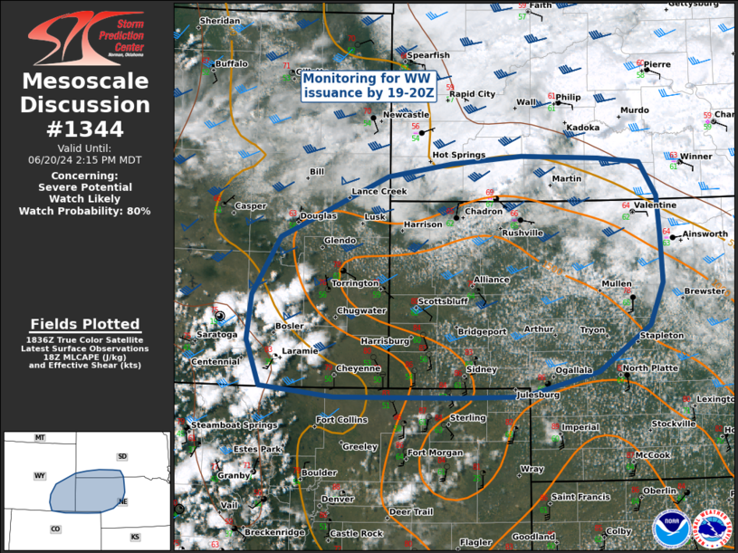
   Areas affected...Eastern Wyoming and Western Nebraska

   Concerning...Severe potential...Watch likely

   Valid 201843Z - 202015Z

   Probability of Watch Issuance...80 percent

   SUMMARY...Eastern WY into W NE and SW SD are being considered for a
   WW this afternoon, as thunderstorms develop on the higher terrain
   and move east into substantial buoyancy and deep layer shear
   supportive of large hail and damaging winds.

   DISCUSSION...Thunderstorm coverage has increased over the last hour
   as convective temperatures have been reached over the higher
   terrain. This activity is expected to progress eastward into the
   richer moisture and MLCAPE > 1500 J/kg, underneath deep layer shear
   of 35-45 kts.

   Given the buoyancy and shear, a few supercells capable of 2-inch
   hail and 70 MPH winds are expected across the highlighted area this
   afternoon. The threat for tornadoes remains low due to high MLLCL
   heights, though a supercell encountering easterly surface winds in E
   WY and W NE could produce a brief tornado. Given the environment and
   storm coverage, WW issuance is anticipated by 19-20Z.

   ..Halbert/Lyons/Hart.. 06/20/2024

   ...Please see www.spc.noaa.gov for graphic product...

   ATTN...WFO...LBF...UNR...BOU...CYS...

   LAT...LON   41490607 41970602 42590561 43250408 43390316 43470214
               43440103 43400043 43040020 42620016 42110013 41650032
               41160106 40900214 40900308 40900483 41010589 41490607
|
|
|
Top/All Mesoscale Discussions/Forecast Products/Home |
|


