|
|
| Mesoscale Discussion 1341 | |
| < Previous MD | |

|
|
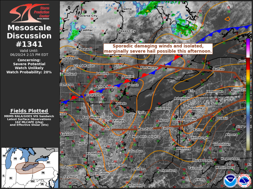
   Mesoscale Discussion 1341
   NWS Storm Prediction Center Norman OK
   1117 AM CDT Thu Jun 20 2024

   Areas affected...southeast Lower MI...north OH...west NY...northwest
   PA

   Concerning...Severe potential...Watch unlikely

   Valid 201617Z - 201815Z

   Probability of Watch Issuance...20 percent

   SUMMARY...Sporadic damaging winds and isolated marginally severe
   hail will be possible with isolated to scattered pulse-type
   thunderstorms surrounding the Lake Erie vicinity this afternoon.
   Severe thunderstorm watch issuance in this region is unlikely, but
   could be warranted if greater clustering becomes apparent.

   DISCUSSION...Pockets of enhanced Cu development are underway to the
   west/south of Lake Erie and along the NY/PA border. With remnant
   MCVs largely tracking north and northeast of these corridors,
   confidence is low in a more concentrated damaging wind threat area
   this afternoon. Deep-layer shear will remain weak south of the
   quasi-stationary front draped from southeast Lower MI into far
   northwest IN, with effective bulk shear from 10-20 kts. This
   suggests pulse-type cells should dominate. Isolated, marginally
   severe hail of 0.75-1.25 inches in diameter will be possible along
   with occasional downbursts from 45-60 mph wind gusts.

   ..Grams/Hart.. 06/20/2024

   ...Please see www.spc.noaa.gov for graphic product...

   ATTN...WFO...BGM...BUF...CTP...PBZ...CLE...ILN...DTX...IWX...
   GRR...

   LAT...LON   42817779 42307732 41867741 41437876 40958021 40818221
               40798383 41168474 42078515 42708459 43148246 42817779
|
|
|
Top/All Mesoscale Discussions/Forecast Products/Home |
|