|
|
| Mesoscale Discussion 1340 | |
| < Previous MD | |

|
|
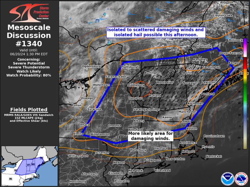
   Mesoscale Discussion 1340
   NWS Storm Prediction Center Norman OK
   1026 AM CDT Thu Jun 20 2024

   Areas affected...parts of New England and NY

   Concerning...Severe potential...Severe Thunderstorm Watch likely

   Valid 201526Z - 201730Z

   Probability of Watch Issuance...80 percent

   SUMMARY...Isolated to scattered damaging winds from gusts of 50-65
   mph, along with isolated hail from 0.75-1.50 inches in diameter will
   be possible this afternoon. A severe thunderstorm watch is likely
   for parts of the region, centered from east NY into south ME.

   DISCUSSION...Low 70s surface dew points remain pervasive in lower
   elevations across central/east NY into ME. Robust diabatic heating
   of this moisture plume will result in moderately large buoyancy with
   MLCAPE of 2000-2500 J/kg becoming common in the next few hours. A
   pair of MCVs embedded within a zonal mid-level flow regime, the lead
   one over the Upper St. Lawrence Valley and an upstream one near the
   Georgian Bay of Lake Huron, should aid in scattered to widespread
   thunderstorm development through the afternoon. Deep-layer shear
   will be weak, especially with south extent, and initial mode will
   predominately be pulse. But some congealing and loosely organized
   multicell clustering may occur where effective bulk shear holds
   around 20 kts, ahead of the lead MCV. The most favored corridor
   appears to be centered on the Champlain Valley into south ME. Strong
   to isolated severe wind gusts of 50-65 mph producing potentially
   scattered tree damage appears to be the primary threat, but isolated
   marginally severe hail will be possible as well.

   ..Grams/Hart.. 06/20/2024

   ...Please see www.spc.noaa.gov for graphic product...

   ATTN...WFO...CAR...GYX...BOX...BTV...ALY...BGM...BUF...

   LAT...LON   42167637 44947430 45117192 45247061 45476931 44666848
               43307011 42457107 41867462 42167637
|
|
|
Top/All Mesoscale Discussions/Forecast Products/Home |
|