|
|
| Mesoscale Discussion 1336 | |
| < Previous MD | |

|
|
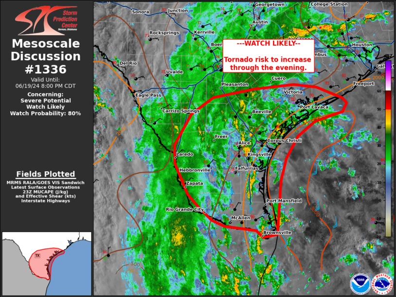
   Mesoscale Discussion 1336
   NWS Storm Prediction Center Norman OK
   0657 PM CDT Wed Jun 19 2024

   Areas affected...Lower/middle Texas Coast and deep south Texas

   Concerning...Severe potential...Watch likely

   Valid 192357Z - 200100Z

   Probability of Watch Issuance...80 percent

   SUMMARY...Tornado risk to increase through the evening as outer
   bands of Tropical Storm Alberto move inland across the lower/middle
   Texas Coast.

   DISCUSSION...Recent radar imagery has shown supercells developing in
   a band of convection just off the middle Texas Coast northeast
   Corpus Christi. At least transient rotation and supercell structures
   are expected to increase as low-level shear strengthens through the
   evening. Forecast soundings show greater low-level shear and
   curvature in hodographs after 00z across much of the area across
   south Texas and inland to the Rio Grande Valley. This will lead to
   an increase in embedded supercells within bands of deeper convection
   and potential risk for tornadoes.  Isolated supercells also may
   develop over the Gulf and move ashore south of the primary band(s).
   A watch is likely to be needed in the next hour.

   ..Thornton/Edwards.. 06/19/2024

   ...Please see www.spc.noaa.gov for graphic product...

   ATTN...WFO...HGX...CRP...EWX...BRO...

   LAT...LON   28629549 28739561 28969621 29039673 28949768 28759863
               28419914 27769953 27389952 26749921 26459893 26229864
               26099836 26019762 25879747 25929714 27049705 27499693
               27969664 28259624 28449560 28629549
|
|
|
Top/All Mesoscale Discussions/Forecast Products/Home |
|
Source link