|
|
| Mesoscale Discussion 1335 | |
| < Previous MD | |

|
|
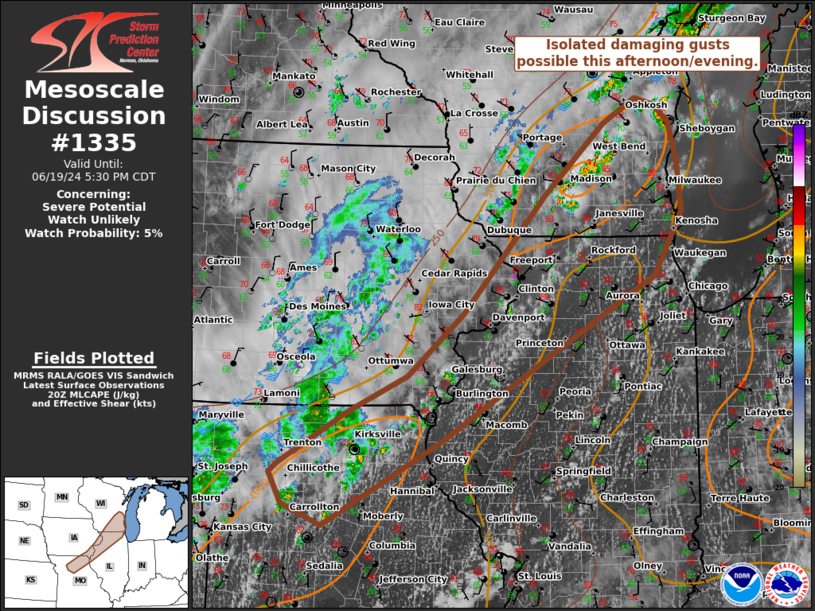
   Mesoscale Discussion 1335
   NWS Storm Prediction Center Norman OK
   0358 PM CDT Wed Jun 19 2024

   Areas affected...portions of the middle to upper Mississippi Valley

   Concerning...Severe potential...Watch unlikely

   Valid 192058Z - 192230Z

   Probability of Watch Issuance...5 percent

   SUMMARY...Scattered storms may be capable of occasional damaging
   gusts this afternoon/evening. Limited potential for storm
   organization should keep the risk isolated.

   DISCUSSION...Across parts of the upper MS Valley, afternoon radar
   imagery shows scattered thunderstorms have developed near a
   slow-moving cold front stretching from southern WI to northern MO.
   Over the past hour, a few of these storms have intensified with a
   noted increase in lightning. Strong diurnal heating and dewpoints in
   the upper 60s to low 70s F ahead of the front have resulted in 1000
   J/kg of MLCAPE. While buoyancy will likely support additional storm
   development and occasional vigorous updrafts, vertical bulk shear is
   rather weak with area VADs sampling generally less than 20 kt. This,
   along with much of the stronger convection being confined near and
   behind the front suggests that storm organization will likely be
   limited. Steep low-level lapse rates in the lowest 2km may support
   occasional stronger downdrafts, especially with any more persistent
   storm clusters. The risk for isolated damaging gusts will likely
   continue into this evening as storm coverage slowly increases.
   However, the limited potential for storm organization suggests a
   weather watch is unlikely.

   ..Lyons.. 06/19/2024

   ...Please see www.spc.noaa.gov for graphic product...

   ATTN...WFO...GRB...LOT...ILX...MKX...LSX...DVN...DMX...EAX...

   LAT...LON   42048810 41888844 40219125 39249301 39489361 39829379
               39929367 40539262 40929178 41649096 42968974 43768886
               44038836 43968808 43768786 43348774 42778769 42048810
|
|
|
Top/All Mesoscale Discussions/Forecast Products/Home |
|
Source link