|
|
| Mesoscale Discussion 1330 | |
| < Previous MD | |

|
|
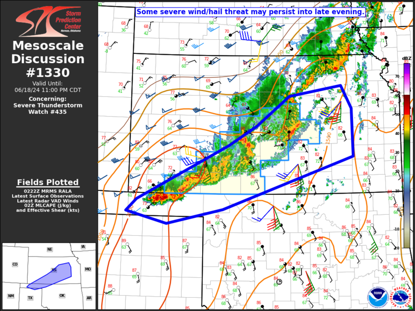
Mesoscale Discussion 1330 NWS Storm Prediction Center Norman OK 0924 PM CDT Tue Jun 18 2024 Areas affected...OK and far northern TX Panhandles into northwest OK...southwest/central/eastern KS Concerning...Severe Thunderstorm Watch 435... Valid 190224Z - 190400Z The severe weather threat for Severe Thunderstorm Watch 435 continues. SUMMARY...Some severe wind/hail threat may persist through late evening. DISCUSSION...A cluster of strong storms is gradually propagating southward across the central/eastern OK Panhandle, and this trend may continue (with some additional backbuilding) as a strong low-level jet remains focused across the region. While deep-layer flow/shear decreases with southward extent, moderate to strong buoyancy will support a continued risk of isolated hail and strong/severe gusts, which may slowly spread into the far northern TX Panhandle and extreme northwest OK. Farther northeast, a couple of bowing line segments that earlier developed over west-central KS appear to be weakening somewhat, though some threat for isolated severe gusts and perhaps some hail may continue beyond the 03Z expiration time of WW 435. Local watch extension may be considered if short-term trends continue to support maintenance of an organized severe risk. ..Dean/Edwards.. 06/19/2024 ...Please see www.spc.noaa.gov for graphic product... ATTN...WFO...TOP...ICT...OUN...DDC...AMA... LAT...LON 36860181 38049933 38479857 39129766 39349623 38849594 37799593 36659948 36340099 36590208 36860181 |
|
|
Top/All Mesoscale Discussions/Forecast Products/Home |
|