|
|
| Mesoscale Discussion 1329 | |
| < Previous MD | |

|
|
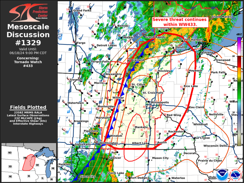
Mesoscale Discussion 1329 NWS Storm Prediction Center Norman OK 0700 PM CDT Tue Jun 18 2024 Areas affected...central/southern Minnesota into western Wisconsin Concerning...Tornado Watch 433... Valid 190000Z - 190200Z The severe weather threat for Tornado Watch 433 continues. SUMMARY...Threat for strong to severe wind continues within WW433. DISCUSSION...A line of thunderstorms continues eastward across Minnesota. Storm mode has largely been linear along an eastward-moving cold front. A few sub-severe clusters continue out ahead of the main line. Ahead of this line, an unstable air mass extends across eastern Minnesota into western Wisconsin with temperatures in the low to mid 80s F and dewpoints in the upper 60s to 70s F. Within this region, surface objective analysis shows MLCAPE around 2000-2500 J/kg. Much of the deep-layer shear remains along and on the cool side of the approaching cold front. Downstream severe threat will be dependent on upscale growth and strength of any developing cold pool within the main line. A watch may be needed east of WW433 if trends show potential for storms to develop a deep cold pool, and increased potential for a damaging-wind threat. ..Thornton/Edwards.. 06/19/2024 ...Please see www.spc.noaa.gov for graphic product... ATTN...WFO...DLH...ARX...MPX...FSD... LAT...LON 43719534 44529506 45559460 46169441 46929368 47319259 47259205 47199174 46679114 46229113 45669122 45139141 44859153 44279195 44019215 43779259 43529313 43509467 43539488 43719534 |
|
|
Top/All Mesoscale Discussions/Forecast Products/Home |
|